The expedition spends the day at a “Bald Pated Prairie” near the present Iowa-Missouri border. The Missouri’s current is measured using a log line, reel, and ship, mosquitoes come and go with the wind, and tumors trouble several of the party.
Log Line, Reel, and Ship
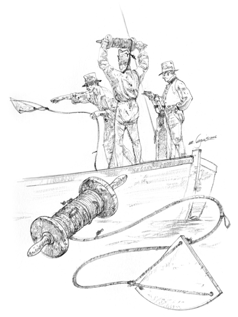
© Michael Haynes, https://www.mhaynesart.com. Used with permission.
Hunting and Fishing
we delay at this place for to hunt & take observations &-C— Several men out hunting eairly this morning—through the aforesaid Ball pated prarie. Capt Lewis Rhode out hunting also, the hunters killed 4 Deer to day
—John OrdwayGutrich [Goodrich] caught two verry fat Cat fish
—William Clark
Taking Astronomical Observations
Captains Lewis & Clark both took Observations, and found it to lay in Latitude 40° 29″ 54 North
—Joseph Whitehouse
Using the Log Line, Reel, and Ship
The Common Current taken with a Log runs 50 fathen in 40″— Some places much Swifter in 30″ and even 20 Seconds of time—
—William Clark
These measurements convert to 5.1, 6.8, and 10.2 miles per hour. See Also Log Line, Reel, and Ship.
Swarms of Mosquitoes
a puff of wind brought Swarms of Misquitors, which disapeared in two hours, blown off by a Continuation of the Same brees.
—William Clark
Troublesome Tumors
Several of the party much aflicted with tumers of different Kinds, Som of which is verry troublesom and dificuelt to cure.
—William Clark