Lewis works in St. Louis, and Clark takes the boats to the Riviére á Dubois—today called Wood River—just below the old confluence of the Missouri and Mississippi rivers. Two canoes of drunk Potawatomis set up camp on the other side.
Leaving St. Louis
Cahokia, December 19th 1803
Dear Sir,
Capt. Clark continuted his route with the party to the river Dubois (distant from St. Louis 18 Miles) in order to erect Cabins for our winter residence at that place (provided it met the description we had received of it).
MERIWETHER LEWIS Capt.
1st U.S. Regt. Infty.[1]Lewis to Jefferson, Donald Jackson, ed. Letters of the Lewis and Clark Expedition with Related Documents: 1783-1854, 2nd ed., (Urbana: University of Illinois Press, 1978), 147.
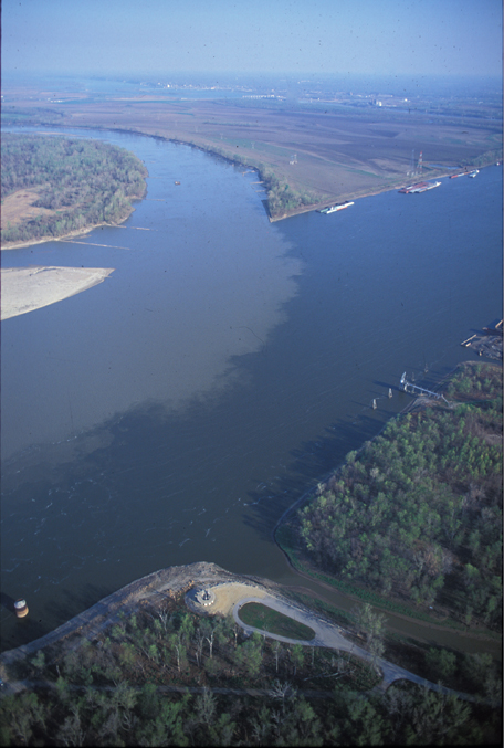
The Wood River
nearly opposit the Missouries I came to in the mouth of a little River called Wood River, about 2 oClock and imediately after I had landed the N W wind which had been blowing all day increased to a Storm which was accompanied by Hail & Snow, & the wind Continued to blow from the Same point with violence.
—William Clark
Potawatomi Travelers
not soon after I had landed two Canoos of Potowautomi Indians Came up on the other Side and landed formed their Camp and three of them in a Small Canoo Came across when the waves was so high & wind blowing with violence that I expected their Canoo would Certounly fill with water or turn over, but to my astonishment found on their landing that they were all Drunk and their Canoo had not received any water.
—William Clark
Hunting Report
The hunders which I had sent out to examine the Countrey in Deferent derections, returned with Turkeys & opossoms and informed me the Countrey was butifull and had great appearance of Gaim.
—William Clark
Experience the Lewis and Clark Trail
The Lewis and Clark Trail Experience—our sister site at lewisandclark.travel—connects the world to people and places on the Lewis and Clark Trail.
Plan a trip related to December 12, 1803:


In present St. Louis, the Jefferson National Expansion Memorial “commemorates Thomas Jefferson’s vision of the continental expansion of the United States” and is a High Potential Historic Site along the Lewis and Clark National Historic Trail managed by the U.S. National Park Service.
Winter Camp at River Dubois (Camp Dubois) is a High Potential Historic Site along the Lewis and Clark National Historic Trail managed by the U.S. National Park Service. The site, near Hartford, Illinois, is managed as Lewis and Clark State Historic Site and is open to the public.
Notes
| ↑1 | Lewis to Jefferson, Donald Jackson, ed. Letters of the Lewis and Clark Expedition with Related Documents: 1783-1854, 2nd ed., (Urbana: University of Illinois Press, 1978), 147. |
|---|

