Expectations
The Deschutes River
Clark’s River: Still “fomeing”
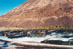
© 2000 VIAs Inc.
It is unlikely that Lewis and Clark saw this very waterfall, for it would have been a 12-mile hike from the river’s mouth. The one they might have seen is about 5 miles from the Columbia. But this is the first one that can be reached by highway today. The Deschutes was crossed by westering travelers just below this place beginning as early as 1826. Since 1863 it has been known as “Sherar’s Falls.” The salmon-fishing platforms are used by Indians from the nearby Warm Springs Reservation. The concrete wall in the foreground is part of a raceway built to facilitate seasonal salmon migrations upriver.
William Clark and his advance detachment reached Weippe Prairie in present Idaho on 20 September 1805, starving from their Bitterroot Range crossing, and planning to hunt and send food back to Lewis and the main party, who were still on the mountainous Northern Nez Perce Trail. The next day, while his men were out hunting, Clark sat down with an unnamed Nez Perce “Cheif” and solicited information about what lay ahead.
The Cheif drew me a kind of chart of the river . . . below a large forks [the Snake River joining the mainstem Columbia] . . . the river passed thro’gh the mountains at which place was a great fall of the water passing through the rocks.[1]Unless otherwise indicated, journal quotations for this portion of the trip are from Clark; either Lewis was not keeping a journal from 21 September 1805 through 17 December 1805, or it has been lost.
This was the first information they had gotten about the existence of Celilo Falls, and it proved to be as misleading as the description they had been given of the Great Falls of the Missouri–an ostensibly singular “great fall of water,” “a most tremendious Cataract.” The captains carried Nicholas King’s map of the lower Columbia (based on a map by explorer George Vancouver), but William Broughton of Vancouver’s party, traveling up the Columbia, had failed to reach the Gorge by two miles. No other white men had ever been there when the expedition arrived. The Nez Perce informant may have condensed Celilo Falls[2]Origins of this name (which the captains apparently never heard) have been lost, but suggestions about its meaning include “echo of falling water,” “sound of water falling on … Continue reading and The Dalles and Cascades beyond them into one location, or Clark’s translation chain may have failed. (Some Nez Perce traveled beyond Celilo and also could have described The Dalles.) So, when the Corps reached Celilo Falls on 22 October 1805, they unknowingly faced a series of four major river obstacles in fifty-some river miles: Celilo Falls, the Short Narrows and Long Narrows that comprise The Dalles and, farther on, the Cascades of the Columbia.
Miller Island and Deschutes Mouth
View southwest, downstream
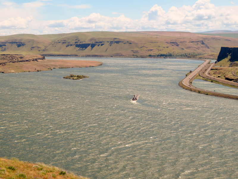
© 2022 by Robert Heacock. Used by permission.
The ragged, steep channel of the native Columbia River is now hidden beneath the windy waters of Lake Celilo–the meaning of the word long lost to memory–which extends from The Dalles Dam, two miles downstream beyond Miller Island (left) and the mouth of the Deschutes River (right).
Deschutes River
Meanwhile, on 21 October 1805 their attention was drawn first to a wide river entering the Columbia from the south, which they eventually learned was called Towarnehiooks by the Indians. Their word meant “enemies,” which was appropriate because their mortal enemies, the Paiutes, lived along its banks. Lewis and Clark explored it a few miles up, soon encountering “a verry Considerable rapid” which Clark described as “an emence body of water Compressd in a narrow Chanel of about 200 yds in width, fomeing over rocks many of which presented their tops above the water.” On their return upriver in April 1806 the captains named it “Clark’s River,” but soon reconsidered that. On 6 May 1806 Lewis decided to reserve Clark’s name for the long tributary of the Columbia that now bears three names–Bitterroot, Clark Fork, and Pend Oreille—and designated this one by its Indian name. But that one didn’t last long either. French-Canadian engagés and traders who began arriving a decade or so later dubbed it Des Chutes—literally, “The Falls,” now spelled Deschutes. The oft-repeated explanation was that the French name referred not to the numerous falls on the lower Towarnehiooks/Clark River, but to the Great Falls five miles below its mouth on the Columbia.
Celilo Falls
The fall salmon run was ending when the Corps arrived at the Great Falls of the Columbia, several miles below the mouth of Towarnehiooks, with some native people still at the river, fishing with gigs and nets and processing their salmon harvest.
Landing on the Columbia’s north side, the expedition had to settle for dog-meat because “the Indians [were] not verry fond of Selling their good fish.” A better trade was made when Lewis exchanged one dugout, a hatchet, and some smaller items, for a high-prowed Columbia River model. The captains instantly recognized how well designed the Indian canoes were for local river conditions. They were “neeter made than any I have ever Seen,” Clark wrote, “and Calculated to ride the waves, and carry emence burthens.” They were “dug thin and are suported by cross pieces of about 1 inch diamuter tied with Strong bark thro’ holes in the sides.”
The next day, 23 October 1805, amid clouds of Fleas attracted by fish skins, men of the Corps crossed the canoes to the Oregon side. They stripped off their clothes so they were able to brush fleas from their bodies, and hauled the empty canoes over a 475-yard portage around Celilo Falls. After paddling down the stretch later known as the “Short Narrows,” they eased the boats down the 8-foot “Great Rapid” with elk-hide ropes prepared especially for just such a purpose. The passage was completed by three o’clock in the afternoon, and camp established below the falls.
Ever since leaving Nez Perce country, the Corps had been accompanied by chiefs Twisted Hair and Tetoharsky, who had volunteered to introduce them to Columbia River tribes. On the 23rd, the chiefs had warned that they “over herd the Indians from below Say they would try to kill us.” The captains ordered the men to check their weapons, and distributed enough ammunition to top off each man’s supply at 100 rounds. The next morning, the chiefs said that, past Celilo Falls, they could no longer speak the languages and, further, were at war with local tribes, so they would be leaving. The captains convinced them to stay for two days, intending to help negotiate a peace treaty.
1806 Return
Headed upstream on 21 April 1806, most of the Corps camped on the north side of the river opposite the island’s west end. The men were somewhat scattered, most of the company leading the ten pack horses they had so far bought, the rest manning the two remaining canoes. While here, Lewis purchased one more horse “for a trifle”–the equivalent, he said, of ten shillings in Virginia currency.
Food was still scarce for native and traveler alike. So was firewood. Lewis characterized the local natives as “poor, dirty, proud, haughty, inhospitable, parsimonious and faithless in every rispect,” and he felt it advisable to treat them menacingly. Out of spite he ordered the spare paddles and poles to be burned in an evening bonfire–a vindictive gesture in this treeless desert where fuel wood was generally non-existent.
Notes
| ↑1 | Unless otherwise indicated, journal quotations for this portion of the trip are from Clark; either Lewis was not keeping a journal from 21 September 1805 through 17 December 1805, or it has been lost. |
|---|---|
| ↑2 | Origins of this name (which the captains apparently never heard) have been lost, but suggestions about its meaning include “echo of falling water,” “sound of water falling on rocks,” and also “blowing sand clouds” after the region’s strong river winds. |
Experience the Lewis and Clark Trail
The Lewis and Clark Trail Experience—our sister site at lewisandclark.travel—connects the world to people and places on the Lewis and Clark Trail.
![]()
This page was funded in part by a grant from the National Park Service's Challenge Cost Share Program.
Discover More
- The Lewis and Clark Expedition: Day by Day by Gary E. Moulton (University of Nebraska Press, 2018). The story in prose, 14 May 1804–23 September 1806.
- The Lewis and Clark Journals: An American Epic of Discovery (abridged) by Gary E. Moulton (University of Nebraska Press, 2003). Selected journal excerpts, 14 May 1804–23 September 1806.
- The Lewis and Clark Journals. by Gary E. Moulton (University of Nebraska Press, 1983–2001). The complete story in 13 volumes.
This site is provided as a public service by the
![]()
Lewis and Clark Trail Alliance
with additional funding from the following:

