Mapping the Rockies was a long process befitting the complexities the two explorers encountered. Two of the most important outcomes of their winter-long studies and inquiries among the “best informed travellers” they interviewed at Fort Mandan reflected their efforts to achieve a conceptual grasp of the Rocky Mountains. One was Lewis’s remarkably complete and detailed “Summary view of the Rivers and Creeks, which discharge thems[elves] into the Missouri” between the Mississippi and the east slope of the Rocky Mountains. The other was Clark’s “Map of part of the Continent of North America Between the 35th and 54th degrees of North Latitude and extending from the 89° Degrees of West Longitude to the Pacific Ocean.”
King’s Map of the Rockies
Figure 1
Nicholas King’s 1803 Map
To see labels, point to the image.
Library of Congress.
Nicholas King’s generalized representation of the Rocky Mountains, copied from Aaron Arrowsmith’s map of 1802, emphasized prominent landmarks on the road that Indians traveled along the eastern front of the range. Many Indians of many nations used this road, now known as the “Old North Trail,” but the information came to Arrowsmith indirectly from a Blackfeet chief in 1801, so the names they bear probably are Blackfeet names, even if originally adapted from other road users. King showed the Rocky Mountains as a single chain lying across the 115th meridian, extending northward from about 46° north latitude, only about 200 miles south of the present international boundary between the U.S. and Canada, at 49° north.
But while the geography of the Rocky Mountains below 46° north was, as King scribed on his map, still “Conjectural,” the geographic features he showed north of that were only rumored—second- third- and fourth-hand hearsay, and maybe some scribbled conjectures. Thus, although it is tempting to speculate on possible correspondences between the western rivers, mountains and landmarks King drew and those we now know by name and place, the results are of dubious value.
The real lesson is more personal. Anyone who has journeyed into personally unfamiliar places, whether on the far side of the world, across the continent, or on the other side of town, has had the same sort of experiences as Lewis and Clark. We ask directions of an accommodating stranger. Perhaps we’re given a little sketch map of the route to take, and we’re sent on our way with a friendly “You can’t miss it!” Sooner or later we’re all caught up in some metaphrase, some little epitome, of Lewis and Clark’s day-by-day, step-by-step odyssey through the Northwest’s mountain barrier. We learn, too, that the discovery of the way is part of the picture of the place (see Indian Spatial Concepts).
Figure 2
Evans’s Four Chains
To see labels, point to the image.
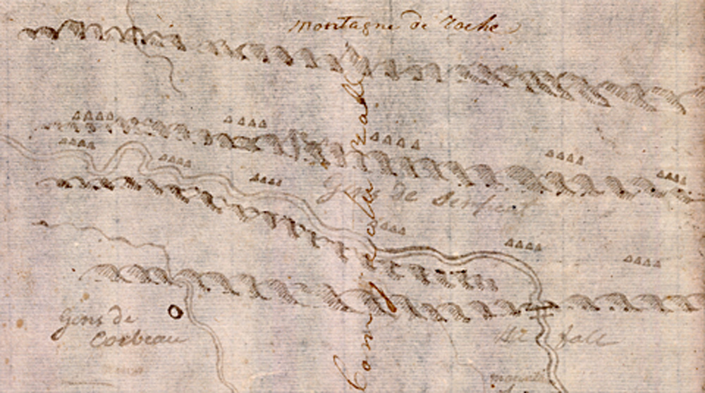
Yale Collection of Western Americana, Beinecke Rare Book and Manuscript Library, Yale University.
Evans’ Four Chains
Lewis and Clark were familiar with the concept of parallel mountain chains penetrated by rivers flowing through gorges or “water gaps,” just as the New River, which rises in northwestern North Carolina, flows through the successive ridges of the Appalachians to join the Kanawha, which in turn empties into the Ohio. John Evans‘s rough sketch must have struck a familiar note for them.
In January 1804 the captains received from President Jefferson a copy of a map made by John Evans, a Scotsman who had accompanied a Spanish-sponsored commercial expedition to the Mandan villages in 1795-97. It was this rough sketch based on descriptions Evans got from Indians there, which expanded on the information about the Rockies that had been available to Aaron Arrowsmith and Nicholas King. Evans understood that they consisted of four parallel chains or ranges of mountains, at least from the source of the Missouri to the point where it left them, above the Great Falls of the Missouri.[1]The idea that the Rocky Mountains consisted of several parallel chains or ranges had been in the lore of Northwestern geography for some time. John Logan Allen, Lewis and Clark and the Image of the … Continue reading
The fact that the word “Conjecturall” is in Clark’s handwriting may be taken to indicate that he was pessimistic about the map’s accuracy.[2]W. Raymond Wood, “The John Evans 1796-97 Map of the Missouri River,” Great Plains Quarterly, Vol. 1, No. 1 (Winter 1981), 48. Nevertheless, from shortly after the Corps of Discovery left the Falls of the Missouri and headed upriver in mid-July, 1805, he and Lewis were predisposed to watch for those “remarkeable” places where, as they put it, the Missouri River “passes through”—or exits, or enters—a “gate” or “gap” in a “chain” of mountains.
Lewis’s Conjectures
Lewis’s narrative outlined the understanding of the mountains that he and Clark had gained from “the Authorities of the best informed Travellers,” beginning at the mouth of the Medicine (now Sun) River, four miles upstream from the uppermost Fall of the Missouri:
About 60 miles further on a direct line nearly S. W. the Missouri passes through the first connected chain of the Rocky mountains and is said to be rapid and shoaly [shallow] from hence to the second chain of the rocky Mountains a distance of 75 miles further, about the same course last mentioned; above this second range of mountains the current of the Missouri is said to be smoth even and gentle. . . .
Still proceeding S. W. about 75 miles further the Missouri divides into three nearly equal branches [the headwaters, or Three Forks of the Missouri] just above a third chain of very high mountains, all these streams are navigable for some distance. the most Nothern is the largest [Jefferson’s River], and is navigable to the foot of chain of high mountains, being the ridge [Lemhi Pass] which divides the waters of the Atlantic from those of the Pacific ocean.[3]Moulton, Journals, 3:368.
Clark’s Conjectures
The captains were thoroughly settled in their quarters at Fort Mandan and suitably sheltered from the bitter below-zero daily temperatures when Clark began work on the map that was to become one of his major achievements that winter.
He may have been inspired by the 17 December 1804 visit of Hugh Heney, or Hené, who had recently gone to work for the North West Company up on the Assiniboine River. “We found Mr. Henny a verry intelligent man,” wrote Clark, “from whome we obtained some Scetches of the Countrey between the Mississippi & Missouri, and Some Sketches from him, which he had obtained from the Indins. to the West of this place.” The very next day he began a draft of the map “I imploy my Self makeing a Small map of Connection &.”
He may have plodded along with his project until 7 January 1805, when, he reported, “the Big White Chef of the Lower Mandan Village, Dined with us, and gave me a Scetch of the Countrey as far as the high mountains, & on the South Side of the River Rejone. . . . I continue to Draw a connected plote from the information of Traders, Indians & my own observation & idea.” A month and a half later, on 17 February 1805, he was ready to draw a first draft: “I commence a Map of the Countrey on the Missouries & its waters. &c—” He proceeded quickly to a final draft, declaring on 1 March 1805, “I am ingaged in Copying a map.”
More details flowed their way after the map was declared done, such as the fragment concerning “Ah-mâh-tâh, ru-shush-sher or the river which scolds at all others,” that caused them considerable confusion for several months after they continued west on 7 April 1805.
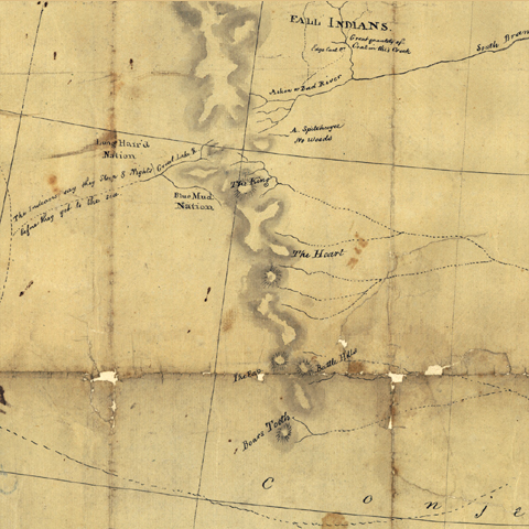
Clark’s 1805 Map
Figure 3
Detail from Clark’s 1805 Map
To see labels, point to the map.
Geography and Map Division, Library of Congress
© State Department Atlas map 32b[4]The original of Clark’s Fort Mandan map of 1805 has been lost, but two of four copies known to have been made by Nicholas King still exist. One is the State Department copy (Atlas map 32a), the … Continue reading
On 19 February 1806, President Jefferson addressed a joint session of the Senate and House of Representatives, and announced he would present to them a letter from Lewis, a “statistical view . . . of the Indian nations inhabiting the territory of Louisiana, and “a general map of the country between the Mississippi and Pacific, from the 34th to the 54th degrees of Latitude,” based on Indians’ information.[5]Donald Jackson, ed., Letters of the Lewis and clark Expedition, With Related Documents, 1783–1854 (2nd ed., Urbana: University of Illinois Press, 1978), 1:299.
Clark evidently began compiling this map after meeting with Hugh Heney at Fort Mandan on 18 December 1804, and continued adding information acquired from other traders, as well as from Indians. He sent it back east on the barge (called the ‘boat’ or ‘barge’ but never the ‘keelboat’) in April 1805. Nicholas King made two copies of it, but neither was ever engraved, so the members of Congress never saw it.[6]Moulton, Journals, Vol. 1, Atlas, 8-9. The detail shown here is from Atlas map 32a, the so-called “State Department copy.” See John Logan Allen, Lewis and Clark and the Image of the … Continue reading
At this point, Clark placed the mouth of the Yellowstone at 107° west longitude, or a little more than 200 miles west of its actual location at 104° west. Lewis arrived there on 25 April 1805, having pushed on overland in advance of the main party, hoping to make the necessary celestial observations without delaying the company’s progress. Unfortunately, clouds obscured the moon, so that half of the exercise had to be abandoned. On his return in August 1806, he was in a hurry to catch up with the main party, and stopped there only long enough to read the note Clark had left him.
“The King,” “The Heart,” “Battle Hills” and “The Tooth” [The Bears Tooth], were landmarks along the Old North Trail, which Indians had identified for earlier travelers. They were about the only topographic features in this part of the continent shown on Nicholas King’s map of 1803, and evidently they were still significant to the Indians who tutored Clark at Fort Mandan. They are all absent from Clark’s 1814 map.
King’s map had placed the northern and southern sources of the Missouri River between 46° and 50° north latitude. Clark has concluded from traders’ and Indians’ accounts that the Yellowstone begins well below the thirty-ninth parallel. Actually, its southernmost source is at about 44° north latitude.
The “war path of the Big Bellies Nation” here crosses the Yellowstone near the Oak-tar-pon-er (now O’Fallon’s Creek); in the map Clark drew from Sheheke‘s information.
To see how Clark’s understanding of the geography of the Northwest evolved, compare this with King’s map of 1803 and Clark’s map of 1814.
The most significant geographical information they acquired that winter is illustrated in the detail from Clark’s 1805 map (Fig. 3). Clark showed “The Rocky or Shining Mountains” beginning at the very top of his map as a single chain somewhat above 53° North Latitude—roughly between Edmonton, Alberta and Prince George, British Columbia—and splitting into four chains starting at about 48° North Latitude, near the Indian road-sign called “The Heart,” near today’s southern boundary of Glacier National Park. He indicated the first, easternmost of the four branches to be a continuation of the single northern chain by applying the name only to that one, leaving the others anonymous. (Even in the comprehensive map he completed for publication with Nicholas Biddle‘s paraphrase of the captains’ journals in 1814, only the easternmost chain bore the name.)
The map Clark compiled at Fort Mandan that winter illustrated all they had confirmed about the lower Missouri, and projected their vague understanding of the still unexplored upper Missouri between the Yellowstone River and the Rocky Mountains. That picture, Lewis explained in a letter to the President, had been “formed from the corresponding testimony of a number of Indians who have visited that country, and who have been separately and carefully examined on that subject, and we therefore think it entitled to some degree of confidence.”[7]Lewis to Jefferson, April 7, 1805. Jackson, Letters, 1:233. He sent a manuscript copy of the 1805 map back to Jefferson on the barge that headed homeward on April 7.
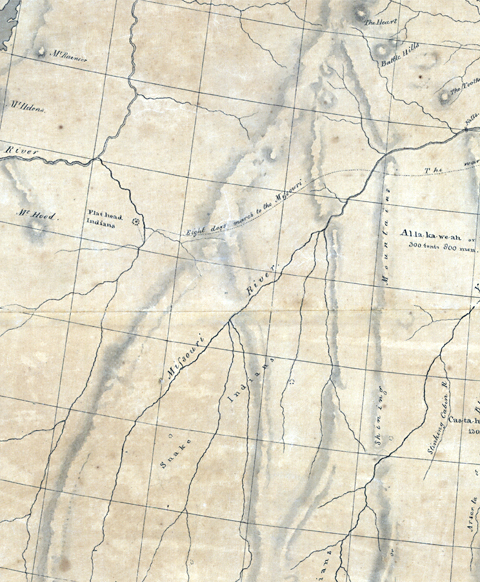
More Conjectures
Figure 4
Detail from Clark’s 1805 Map
To see labels, point to the map.
Library of Congress
At Fort Mandan during the previous winter, Clark could only guess at where to place key geographic elements within the framework of his graticule—that grid of parallels and meridians he used to organize his cartographic flattening of this little corner of the earthly sphere. For that reason it is idle for us to try to reconcile his hypothetical chart of the Missouri and the Rockies with the list of elements he and Lewis had gleaned from beyond a vast cultural and linguistic gulf. It is equally fruitless to compare his map with what we have come to know about the river and the mountains since 1806.
For example, consider the two triple forks of the Missouri River: If the one north of the “3rd Chain of the mountains” is really the Three Forks they named, then the one south of that third chain must be, from left to right, the Big Hole (their “Wisdom”) River, the Beaverhead (the continuation of their “Jefferson’s”) River, and the Ruby (their “Philosophy”) River. But if that is so, then the fourth and fifth gates, which should be south of that, are much too far north, even if they are proportionately in the correct position.
These imponderables simply deepen the mystery of the expedition, and heighten the dauntless courage of both of its leaders.
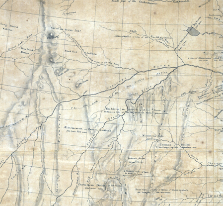
The 80 Ranges in Montana and Idaho
In one sense, all of the mountains they saw in western Montana and northern Idaho, taken together, are usually considered part of the Northern Rockies, one of five regional units of the cordilleran backbone of Western North America. From a different perspective there are at least 89 separate, named mountain ranges in the Northern Rockies alone, extending a total of more than 250 miles in width. Those ranges were not all created at the same time, nor from a single geological event. Each can be identified in terms of the kinds and ages of rocks they contain, and the apparent degrees of erosion and other processes that have affected them since they began to appear. Finally, and most important as far as following the captains’ progress through them is concerned, the demarkation between a given range and its neighbors are often indefinably vague.
The understanding of those processes and characteristics is what both American and European scientists, who were steadily putting the era of Biblically-inspired Creationism behind them, were only beginning to achieve at the turn of the 19th century, and Lewis and Clark were not even neophytes in that fraternity. Although they carried a copy of Richard Kirwan’s Elements of Mineralogy (2nd edition, 1794), on the expedition, it was a basic laboratory manual, and was of little practical use to them in identifying and interpreting the rocks they walked on, not to mention the mountains they met.[8]John C. Greene, American Science in the Age of Jefferson (Ames: Iowa State University Press, 1984), 218-252. Their guidebook to Western geography was simply anecdotal and incomplete. Their task was to fill in the facts as they discovered them.
Figure 5
Mountain Ranges in Montana and Idaho
To see a range name, point to its number or use the index below.
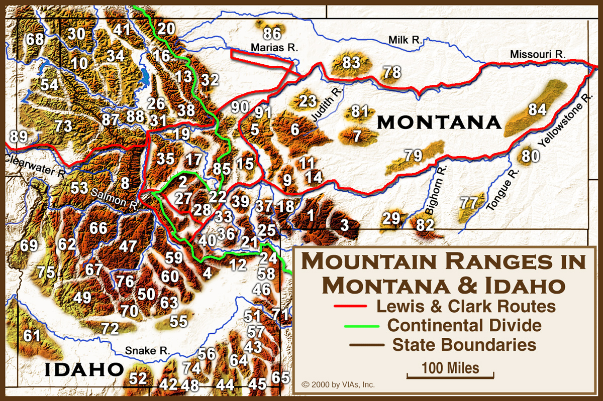
- Absaroka—MT—1
- Adel—MT—9
- Albion—ID—42
- Anaconda—MT—2
- Aspen—ID—43
- Bannock—ID—44
- Bear River—ID—45
- Bears Paw—MT—83
- Beartooth—MT—3
- Beaverhead—MT—4
- Belt, Big—MT—5
- Belt, Little—MT—6
- Big Hole—ID—46
- Bighorn—MT—82
- Bighorn Crags—ID—47
- Big Sheep—MT—84
- Birdtail—MT—90
- Bitterroot—MT—8
- Black Pine—ID—48
- Boise—ID—49
- Boulder—ID—50
- Boulder—MT—85
- Bridger—MT—9
- Bull—MT—79
- Cabinet—MT—10
- Caribou—ID—51
- Cassia—ID—52
- Castle—MT—11
- Centennial—MT—12
- Coeur d’Alene—ID/MT—54
- Clearwater—ID—53
- Craters of the Moon—ID—55
- Crazy—MT—14
- Deep Creek—ID—56
- Elkhorn—MT—15
- Flathead—MT—16
- Flint Creek—MT—17
- Gallatin—MT—18
- Garnet—MT—19
- Glacier Nat’l Park—MT—20
- Gravelly—MT—21
- Grays Lake—ID—57
- Henry’s Lake—ID—58
- Highland—MT—22
- Highwood—MT—23
- Judith—MT—81
- Lemhi—ID—59
- Lionhead—MT—24
- Little Rockies—MT—78
- Lost River—ID—60
- Madison—MT—25
- Mission—MT—26
- Ninemile Divide—MT—87
- Owyhee—ID—61
- Palouse Range—ID—89
- Payette Crest—ID—62
- Pioneer—ID—63
- Pioneer, East—MT—28
- Pioneer, West—MT—27
- Portneuf—ID—64
- Pruess—ID—65
- Pryor—MT—29
- Purcell—MT—30
- Rattlesnake—MT—31
- Reservation Divide—MT—88
- Rocky Mountain Front—MT—32.
- Rosebud—MT—77
- Ruby—MT—33
- St. Joe—ID—73
- Salish—MT—34
- Salmon River—ID—66
- Sapphire—MT—35
- Sawtooth—ID—67
- Selkirk—ID—68
- Seven Devils—ID—69
- Smoky—ID—70
- Snake—ID—71
- Snowcrest—MT—36
- Snowy—MT—7
- Soldier—ID—72
- Spanish Peaks—MT—37
- Sublette—ID—74
- Swan—MT—38
- Sweet Grass Hills—MT—86
- Tendoy—MT—40
- Tobacco Root—MT—39
- West—ID—75
- White Cloud—ID—76
- Whitefish—MT—41
- Wolf—MT—80
Lewis’s Bearings
| To the point at which the Missouri first enters the Rocky Mountains | S. 28° W. | 25 mi. |
| To the termineation of the 1st Chain of Rocky Mountains; northwardly, being that through which the Missouri first passes | N. 73° W. | 80 |
| To the extremity or tirmineation of the 2cd Chain of the Rocky Mountains | N. 65° W. | 150 |
| The direction of the 1st Chain of Rocky Mouts. from S. 20 E. | N. 50° W. | 200 |
| The direction of the 1st Chain from S. 20 E. to N 20 W.[9]Concerning this and the following line, Lewis wrote “the Southern extremites of these ranges not visible and believe they continue probably to mexico [that is, New Mexico],” which … Continue reading | – | – |
| The direction of the 2cd Do. from S 45 E. to N. 45. W.– | – | – |
| To Fort mountain [Square Butte] | S. 75° W. | 8 |
Above the Great Falls on 14 July 1805, while some of the men completed the two new dugout canoes they had hewn to replace the abandoned experimental “iron boat,” Lewis scrambled up the steep, rocky, 250-feet-high bluff that crowds the northwest bank of the river there. Once he surmounted that formidable height, only a gently sloping plain lay before him—no harsh topography to interfere with his hike. The “conspicuous eminence” he wrote of in his journal that night would have been conspicuous only because it was a little higher than the flat terrain surrounding it. There, with compass and probably spyglass in hand, he studied what he took to be three of the anticipated four chains of the Rocky Mountains.[10]According to Professor Bergantino, a likely place is a nameless elevation (3621′) about three and one-half miles from the brink of the bluff, at 47°27’59” N, … Continue reading
At first glance Lewis’s chart appears methodical and clear, but actually it is quite puzzling. Robert Bergantino explores Lewis’s conundrum:
Lewis’s bearing to the point at which the Missouri leaves the first chain is 6 degrees too far west of the actual (after correcting for 16 degrees East magnetic declination), but not bad for a pocket compass. Similarly, his bearing to the termination of the first chain, northerly, is within a few degrees of the farthest north that he could have seen; the distance is about 10 to 15 miles too long, but very good for an estimate.
I have no idea what Lewis thought he was seeing for the termination of the second chain150 miles away to the northwest. His bearing (corrected for 16 degrees East) puts it at or near Two Ocean Glacier on the Continental divide, at a latitude about midway between Chief Mountain in Glacier National Park, and Babb, one of the park’s eastern entrances. There is absolutely no way he could have seen this to take a bearing to it. Was he seeing a cloud—sort of like the island or landmass Columbus’s crew thought they saw, long before they finally made landfall? Furthermore, looking southward, the Little Belts, Big Belts, and ‘Adel’ mountains near Cascade and Hardy are easily distinguishable, but to me, nothing in that direction looks like a ‘second chain.’ Was he merely speculating on its location and bearings? Or was his impression of these mountains so strongly influenced by what he had been told at Fort Mandan that he was capable of ‘seeing things’?
A distance of 200 miles to the most distant point of the third chain locates it in Alberta at 49 degrees 49 minutes north, 113 degrees 55 minutes west. But the crest of Teton Ridge about 7 or 8 miles west of Dutton, Montana, and only 35 miles away, would have prevented him from seeing anything farther north. So what did he see—or think he saw? It certainly wasn’t a mountain, or a third chain of mountains. And he must have known that, considering the earth’s curvature, a mountain would have to rise about 20,000 feet (6,096 m) above his own elevation on the bench above the river, to be seen at that distance. Did he take those bearings and estimated distances for the second and third chains from some map he had that we don’t know of?
In any case, from that time on the contrasts between the simplicity of the Indians’ directions and the complexity of what they really found is a measure of the bewildering confusion they must have felt but never wrote of. How many chains of mountains did they pass through, really?
Lewis, as if reluctant to dismiss the idea of the Rocky Mountains that he and Clark had constructed back at Fort Mandan, continued to remark upon the more conspicuous places where rivers appeared to penetrate a given chain of mountains. On the first day after leaving Travelers’ Rest campsite en route back to the Falls of the Missouri in July 1806, Lewis followed the east branch of Clark’s River (now the Clark Fork of the Columbia) through the Missoula Valley to the point where it “enters the mountains or where the hills set in near it on either side”; he was at the mouth of the defile that in another few decades would earn the name given it by French-Canadian trappers, Port d’ Enfer, or Hell’s Gate. Three days later, after crossing the “prarie of the knobs,” he reached the point at which the Cokalarishkit, or River of the Road to the Buffalo, “leaves the extensive plains and enters the mountains.”
Clark’s Rocky Mountain Gates
During the winter of 1805-6 at Fort Clatsop the captains worked on a list of “remarkable places” they had passed while ascending the Missouri river, including “the distance from one place to another,” the “Distance to the mouth of Missourie,” and “Latitude & remarks &c.” Clark’s third and final draft of the list included gaps and gates through six mountain chains (excerpted below),[11]Moulton, Journals, 6:449-51. but did not include the gap—Lemhi Pass—in the main, westernmost chain in the same context, but described it only as “a Dividing ridge of the rock M.” The six “remarkable places” are listed as follows; we omit the intervening places, summarize the mileages, and include the Three Forks as a point of reference:
| 1. | to the Rockey Mountains at Pine Island rapid [July 16, 1805] | – | 2668¼ | 46°42’14.7 |
| 2. | to the Great Gate of the Rock Mouts. river confined in a narrow channel between Clifts of 1200 feet high [July 19] | [85] | 2712 | W. Clark across S[ai]d mtn[s]. |
| 3. | to the Little Gate of the Mountain [July 25] | [109] | 2821 | we saw a horse |
| – | to the three forks of Missouri . . . [July 27] | [27] | 2848 | . . . 45°22’34” N |
| 4. | to the Narrows of the 3d Mountain [August 1] | [32] | 2880 | M.L. go a head |
| 5. | to the 4th Gap of the Mountain [August 15] | [178] | 3058 | Saw Several rattle snakes |
| 6. | to a rapid at the narrows of 5th Mtn. [August 16] | [27] | 3085 | a bad rapid for half a mile |
Clark’s Final Map
It is interesting that despite the impact of the more imposing gates of the rocky mountains upon Lewis, as well as upon generations of travelers since then, the place did not appear on the expedition’s final map. Perhaps that was only because Clark personally never saw the place. But even the mountains west of the river, through which he detoured around Lewis’s landmark, are absent. Had his concept of the Rocky Mountains simply gotten too crowded?
That question aside, John Logan Allen has aptly summarized the overall importance of Clark’s cartographic essay:
Of all the alterations in American images of the western part of the continent that resulted from the travels of Lewis and Clark, none were greater nor more observable on Clark’s map than those pertaining to the mountains of the interior. The simplistic and generalized range of the Stony or Shining or Rocky Mountains gave way to a complex series of mountains and hills, some of which were identified as part of the distinct region of the Rockies and others as outliers of that mighty range. The hypothetical geography upon which the Passage to India had been predicated for well over a century was eliminated from American geographical thought after Lewis and Clark.[12]Allen, 383. It remained for fur trappers and traders such as William Ashley, Jedediah Smith, and especially Warren Ferris to begin filling in the blanks and replacing some of Lewis and Clark’s … Continue reading
In the less than two years between their arrival at Fort Mandan in 1804 and their return to the High Plains in 1806, Lewis and Clark’s concept of the Northern Rockies had emerged from their studies and experiences into a vast matrix of “chains.” It was by no means faultless, but it was firm enough to give the legions of explorers and traders who came next a strong indication of the challenges they might encounter. Lewis summed them up in the letter he wrote to an unknown correspondent in October of 1806:
The Passage of 320 M. from the Missesourii to the Kooskooskee is the more formidable part of the Track proposed across the Continent, of this distance 200 M. is along a good Road and 140 M. over tremendous Mountains, which for 60 miles are covered with eternal Snows; however a passage over those Mountains is practicable from the latter part of June to the last of September.
He concluded with what he must have meant to be encouraging words: “The cheap rate at which Horses are to be obtained from the Indians of the Rocky Mountains & west of them, reduces the Expences of Transportation over this Passage to a mere Trifle.”[13]Jackson, Letters, 1:326.
Notes
| ↑1 | The idea that the Rocky Mountains consisted of several parallel chains or ranges had been in the lore of Northwestern geography for some time. John Logan Allen, Lewis and Clark and the Image of the American Northwest (New York: Dover, 1975), 43, 55, 79, 142-43, 169, 170, 177, 250-51. |
|---|---|
| ↑2 | W. Raymond Wood, “The John Evans 1796-97 Map of the Missouri River,” Great Plains Quarterly, Vol. 1, No. 1 (Winter 1981), 48. |
| ↑3 | Moulton, Journals, 3:368. |
| ↑4 | The original of Clark’s Fort Mandan map of 1805 has been lost, but two of four copies known to have been made by Nicholas King still exist. One is the State Department copy (Atlas map 32a), the other the War Department copy (Atlas map 32b). Another version which lacks Clark’s topographic features, was printed by Arnold Hague in 1887 (Atlas map 32c). |
| ↑5 | Donald Jackson, ed., Letters of the Lewis and clark Expedition, With Related Documents, 1783–1854 (2nd ed., Urbana: University of Illinois Press, 1978), 1:299. |
| ↑6 | Moulton, Journals, Vol. 1, Atlas, 8-9. The detail shown here is from Atlas map 32a, the so-called “State Department copy.” See John Logan Allen, Lewis and Clark and the Image of the American Northwest (New York: Dover, 1975), 97–104. Two of King’s copies of Clark’s 1805 Fort Mandan map are now extant; see Moulton, op. cit., 32a and 32b. |
| ↑7 | Lewis to Jefferson, April 7, 1805. Jackson, Letters, 1:233. |
| ↑8 | John C. Greene, American Science in the Age of Jefferson (Ames: Iowa State University Press, 1984), 218-252. |
| ↑9 | Concerning this and the following line, Lewis wrote “the Southern extremites of these ranges not visible and believe they continue probably to mexico [that is, New Mexico],” which indicates that, King’s map notwithstanding, Lewis was inclined to favor the theory that eventually was confirmed as fact by later explorers. |
| ↑10 | According to Professor Bergantino, a likely place is a nameless elevation (3621′) about three and one-half miles from the brink of the bluff, at 47°27’59” N, 111°27’39″W, in Township 20 North, Range 2 East, Section 22, SW ¼ of SE ¼. The bluff is composed of irregularly eroded layers (mostly sandstone, with some shale) of the lower two members of the Cretaceous-age Blackleaf Formation. Dr. Bergantino is a Research Associate Professor and Hydrogeologist at Montana Tech, in Butte, Montana. |
| ↑11 | Moulton, Journals, 6:449-51. |
| ↑12 | Allen, 383. It remained for fur trappers and traders such as William Ashley, Jedediah Smith, and especially Warren Ferris to begin filling in the blanks and replacing some of Lewis and Clark’s conjectures during the 1830s. Ferris, who traveled throughout the Northern Rockies for six years, 1830-35, produced one of the most detailed charts of all. |
| ↑13 | Jackson, Letters, 1:326. |
Experience the Lewis and Clark Trail
The Lewis and Clark Trail Experience—our sister site at lewisandclark.travel—connects the world to people and places on the Lewis and Clark Trail.
![]()
This page was funded in part by a grant from the Montana Cultural Trust.
Discover More
- The Lewis and Clark Expedition: Day by Day by Gary E. Moulton (University of Nebraska Press, 2018). The story in prose, 14 May 1804–23 September 1806.
- The Lewis and Clark Journals: An American Epic of Discovery (abridged) by Gary E. Moulton (University of Nebraska Press, 2003). Selected journal excerpts, 14 May 1804–23 September 1806.
- The Lewis and Clark Journals. by Gary E. Moulton (University of Nebraska Press, 1983–2001). The complete story in 13 volumes.
This site is provided as a public service by the
![]()
Lewis and Clark Trail Alliance
with additional funding from the following:

