Fort Mandan, ND Chief Sheheke brings a sketch of the Yellowstone River country and provides information which Clark uses to draw a map of that river system.
Mapping the Missouri: Winter Afternoon at Fort Mandan
36″ x 58″ oil on canvas
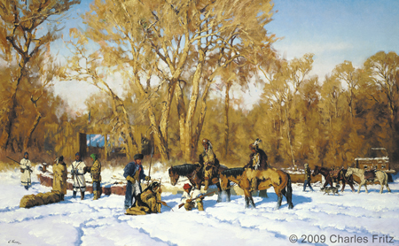
© 2009 by Charles Fritz. Used by permission.
The River Roche Juane[1]Originally aired weekdays by Yellowstone Public Radio during the Bicentennial observance of 2003-2006. Narrated by Hal Hansen. Scripts by Whit Hansen and Ed Jacobson. Produced by Leni Holliman. © … Continue reading
A Very Cold Day
a verry Cold clear Day, the Themtr Stood at 22 d below 0 wind N W., the river fell 1 inch Several indians returned from hunting
—William Clark
Sheheke’s Map
To see labels, point to the image.
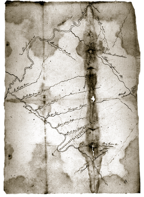
Beinecke Rare Book and Manuscript Library, Yale University.
Big White’s Map
Big White Chef of the Lower Mandan Village, Dined with us, and gave me a Scetch of the Countrey as far as the high mountains, & on the South Side of the River Rejone, he Says that the river rejone recves 6 Small rivers on the S. Side, & that the Countrey is verry hilley and the greater part Covered with timber, Great numbers of beaver &c.—
—William Clark
Returning Hunters
in the evening the three men returned who had been down the River a hunting. had killed one wolf which they eat as they had nothing else with them. they killed also 2 Deer and one buffalo but had Suffered considerable with the cold.
—John Ordway
Celestial Observations
Observed time and distance of
‘s and
‘s nearest limbs, with Sextant.
—Meriwether Lewis
Weather Diary
Ther. at Weather Wind at Thert. at 4 P.M. Weather Wind at 4 P.M. River 22 below [0] fair N W 14 below [0] fair W fall 1 in. —Meriwether Lewis[2]To assist the reader, the editor of this web page has omitted the date column, merged the “River” columns, and spelled out some abbreviations.


Fort Mandan is a High Potential Historic Site along the Lewis and Clark National Historic Trail managed by the U.S. National Park Service. The North Dakota Department of Parks and Recreation manages a modern reconstruction and the Lewis and Clark Interpretive Center located at US Hwy 83 and ND Hwy 200A.
Knife River Indian Villages National Historic Site is a High Potential Historic Site along the Lewis and Clark National Historic Trail managed by the U.S. National Park Service. A unit of the National Park System, the site is located at 564 County Road 37, one-half mile north of Stanton, North Dakota. It has exhibits, trails, and a visitor center.
Notes
| ↑1 | Originally aired weekdays by Yellowstone Public Radio during the Bicentennial observance of 2003-2006. Narrated by Hal Hansen. Scripts by Whit Hansen and Ed Jacobson. Produced by Leni Holliman. © 2003 by Yellowstone Public Radio. |
|---|---|
| ↑2 | To assist the reader, the editor of this web page has omitted the date column, merged the “River” columns, and spelled out some abbreviations. |