In Synopsis Part 4, they trade for horses with Sacagawea’s people, cross the Bitterroot Mountains, and canoe to the Pacific Ocean.
Sacagawea’s People
His Sister’s Son
Cameahwait, Sacagawea, and Jean Baptiste Charbonneau (cropped)
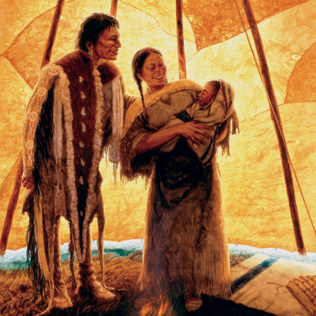
© 2006 Michael Haynes. Reproduction prohibited without artist’s permission.
Watercolor, 24 by 36 inches. The artist may be contacted at Michael Haynes, Historic Art
Everything appeared to astonish Sacagawea‘s people, William Clark wrote: the appearance of the men, their weapons, the canoes, his own black servant, York, and Meriwether Lewis‘s dog, Seaman. Surely, most astonishing to all present was the mutual recognition of Sacagawea and Cameahwait, sister and brother.
Negotiations were difficult, but Lewis now enjoyed the “flattering prospect” of obtaining enough horses to carry them and their baggage over the portage of then-unknown length. Cameahwait, though short of horses, promised to do what he could. Hearing from the Indians that the water route west of the divide was impassable, Lewis sent Clark and eleven axmen ahead, across the pass and down the Lemhi and Salmon rivers, prepared to build canoes if their informants were mistaken. Within six days Clark was “perfectly satisfied as to the impracticality of this route either by land or water.” The alternative was to follow the Lemhi Shoshones‘ suggestion: to head north out of the Lemhi valley, over the mountains and down the Bitterroot valley, and westward on an old, arduous Indian trail over present-day Lolo Pass, toward another headwater of the Columbia River.
With twenty-nine horses and several Shoshone guides, that’s what they did. En route, at Ross’ Hole in the upper Bitterroot valley, they bought eleven more horses from a large band of friendly Salish Indians who uttered, Clark noticed, “a gugling kind of languaje Spoken much thro the Throught.”
Bitterroot Crossing
Lolo Trail, Bitterroot Mountains
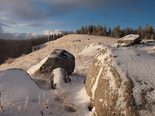
© 2009 by Kristopher Townsend. Permission to use granted under the Creative Commons Attribution-Share Alike 4.0 International license.
Triumph over the Mountains
Produced by Joseph A. Mussulman
Pausing at a spot they called Travelers’ Rest, near the mouth of Lolo Creek, Lewis sent a party of men to inspect its juncture with today’s Clark Fork River, ten miles north, at the outskirts of present-day Missoula. The rugged topography of western Montana was coming into focus. But why didn’t the expedition descend the Clark Fork, which Lewis rightly figured flowed northwest to the Columbia River, and which provides, via Lake Pend d’Oreille, an all-water route to the Pacific? The answer is that no salmon were found in the Bitterroot River, which indicated to the leaders that there must be a considerable impediment in the form of a waterfall.
So the expedition turned west, on what would indisputably be the most exhausting and debilitating segment of the entire journey, the eleven-day passage across the Bitterroot Mountains to the Clearwater River near present-day Orofino, Idaho. The portion of the Lolo Trail east of the crest of the Bitterroots was relatively easy going. Thereafter, the explorers faced virtually impenetrable forested mountains, early snow and bitter cold, and an absence of wild game that forced them to kill and eat three of their horses. Up until then they had relied on as much as eight pounds of fresh meat per man per day to maintain their stamina, but the mountains were barren of game. The elk, deer, and grizzly bear that once shared the vast plains with the bison herds had not yet been forced into the mountains where they live today. By the eleventh day, the men were on the brink of starvation. But they ultimately reached Weippe Prairie, at the edge of the timber a thousand feet above the Clearwater River, where they came upon a band of friendly Nez Perce Indians. The Nez Perce were graciously hospitable to the helplessly weak and hungry men, though the Indians’ usual diet of dried fish and camas roots didn’t sit well on their stomachs.
Clearwater and Snake Rivers
Clearwater River
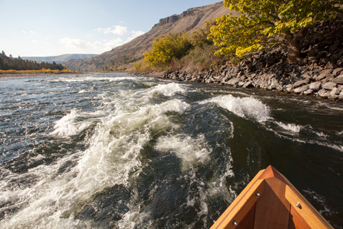
© 13 October 2013 by Kristopher K. Townsend. Permission to use granted under the Creative Commons Attribution-Share Alike 4.0 International license.
The men set up camp opposite the mouth of the North Fork of the Clearwater River, and as the sick recovered they pitched in to help the able-bodied work on five new dugout canoes. Leaving their horses in the care of Chief Twisted Hair, they set out on the seventh of October, down the Clearwater to the Snake River. There were numerous rapids to navigate—those on the Snake now replaced with slackwater behind four dams—but nine days later they sailed into the mighty Columbia River. In lieu of game, they fattened themselves on the meat of dogs purchased from the Indians, as many as forty at a time!
What they discovered west of the Rockies was radically different from what they had had any reason to expect. First, the high, arid, and inhospitable Columbia Plateau. Then the awesome Cascade Range, dominated by lofty peaks such as Adams, Jefferson, St. Helens, and Hood, and penetrated by the precipitous Columbia River Gorge, with its powerful thermal winds. Finally, the damp and foggy climate of the coastal range. For more, see The Clearwater and Snake Rivers.
Down the Columbia River
Castle Rock on the Columbia, below the Cascades
Beacon Rock
by Henry Warre (1819–1898)
![]()
Great Joy at Pillar Rock
Produced by Joseph A. Mussulman
They had looked forward to a relatively easy float from the divide to the Pacific Ocean. On the contrary, of all the rough water the journalists recorded, the roughest of all was the fifty-five-mile stretch that began with the thirty-eight-foot Celilo Falls, at the east end of the Columbia Gorge. Next came The Dalles, at the modern Oregon city of the same name, consisting of the quarter-mile-long Short Narrows, that Clark called an “agitated gut Swelling, boiling & whorling in every direction.”
Below that came three miles of the equally dangerous Long Narrows. After a three-day respite at “Fort Rock Camp” they tackled the final obstacle, the Cascades of the Columbia, or Grand Rapids” four continuous miles of chutes and falls that required two days to descend. We are left only to imagine their experiences, for today all this been submerged under slow-moving waters impounded by John Day, The Dalles, and Bonneville dams. For more, see down the Columbia.
Most remarkable of all was the dense population of Indians strung out along the riverbanks, or concentrated in trading centers reeking with the smell of drying salmon and resounding with the rattle of unfamiliar languages: the Yakamas, Wanapums, Walla Wallas, Umatillas, Wascos and Wishrams, Teninos, Watlalas, Multnomahs, Kathlamets, and Wahkiakums. Some of them were congenial enough toward the American tourists, but most, especially in the Short and Long Narrows of the Columbia River, were tough, scrappy traders accustomed for centuries to exacting tolls from all travelers. Within the past few years their exchanges with coastal Indians had brought them Euro-American goods—wool clothing and blankets, brass and copper kettles, and a few guns.
Emerging from the Columbia Gorge on November second, they found themselves in tidewater at Beacon Rock. On the seventh, their eagerness to reach their long-sought goal duped them into mistaking the broad upper estuary of the Columbia for the ocean itself. But the closer they got to the Pacific, the worse the picture got. It was, Clark mused bitterly, not peaceful at all, but “tempestuous and horiable.” Storms pinned them against rugged northern shorelines for two wet and hungry weeks. They worked their way back upstream to the relative shelter of some islands and crossed to the south side.
Lewis went on ahead in the small dugout to try to locate a suitable winter campsite, finding one at last on a piece of high ground amid the bogs and bays a few miles west of modern Astoria, Oregon. The party buckled down to build a fort, and set up the salt works over on the beach at the modern resort town of Seaside, Oregon. Meanwhile, they gathered meat, tanned hides, and carved out arms-length relationships with the nearby Clatsop and Chinook villagers.
Fort Clatsop Winter
Pacific Ocean from North Head
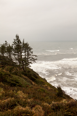
© 2012 by Kristopher K. Townsend. Permission to use granted under the Creative Commons Attribution-Share Alike 4.0 International license.
The Corps finally settled into their Fort Clatsop quarters at Christmastime. By candlelight the captains caught up on a backlog of journalizing, botanical note-taking, and mapmaking. Clark calculated they had traveled 4,132 miles in 554 days, from Wood River to the mouth of the Columbia.
Winter at Fort Clatsop was dull, dreary and wet, but it provided time for the captains to think about what they had learned and to organize the return trip. From the time Lewis reached the Great Falls of the Missouri on 13 June 1805, until the party emerged from the Rockies at Weippe Prairie on 22 September 1805, the expedition had spent 101 days and traveled nearly a thousand circuitous miles, on rivers that were not practicably navigable, and across “those tremendious mountains.” Surely there was a faster way. Accordingly, the captains decided that when they had recrossed the unavoidable Bitterroot Mountains, they would divide the expedition at Travelers’ Rest.
Lewis would take a more direct overland route to the Falls, then explore the Marias and descend the Missouri. Clark would retrace the expedition’s steps to Three Forks of the Missouri, ascend the Gallatin River, cross over Bozeman Pass into the Yellowstone River valley, and head downriver. The Corps expected to reunite at the confluence of the Missouri and the Yellowstone on or about 5 August 1806. Like a scientific theorem the captains had postulated the geography of the region; now they would uncover the proof.
Experience the Lewis and Clark Trail
The Lewis and Clark Trail Experience—our sister site at lewisandclark.travel—connects the world to people and places on the Lewis and Clark Trail.
![]()
This page was funded in part by a grant from the National Park Service's Challenge Cost Share Program.
Discover More
- The Lewis and Clark Expedition: Day by Day by Gary E. Moulton (University of Nebraska Press, 2018). The story in prose, 14 May 1804–23 September 1806.
- The Lewis and Clark Journals: An American Epic of Discovery (abridged) by Gary E. Moulton (University of Nebraska Press, 2003). Selected journal excerpts, 14 May 1804–23 September 1806.
- The Lewis and Clark Journals. by Gary E. Moulton (University of Nebraska Press, 1983–2001). The complete story in 13 volumes.
This site is provided as a public service by the
![]()
Lewis and Clark Trail Alliance
with additional funding from the following:

