Dismal Nitch and Baker Bay, WA John Colter informs the captains that a better encampment site is not far down the river. Lewis and four others go there to look for ships. Because of the constant rain, everyone’s clothing rots away.
Situation Miserable[1]Originally aired weekdays by Yellowstone Public Radio during the Bicentennial observance of 2003-2006. Narrated by Hal Hansen. Scripts by Whit Hansen and Ed Jacobson. Produced by Leni Holliman. © … Continue reading
Columbia River from Dismal Nitch
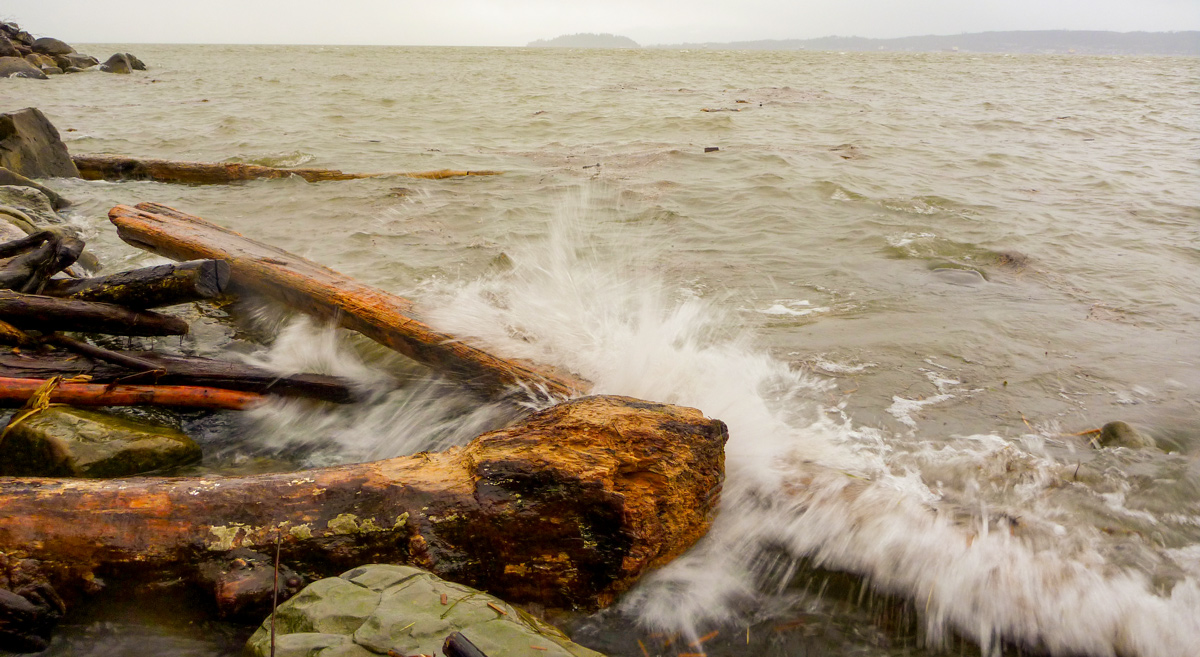
© 18 December 2010 by Kristopher K. Townsend. Permission to use granted under the Creative Commons Attribution-Share Alike 4.0 International license.
Four miles across the Columbia River can be seen Tongue Point.
Colter’s Gig and Basket
5 [Chinook] Indians Came up in a Canoe, thro’ the waves, which is verry high and role with great fury— They made Signs to us that they Saw the 3 men we Sent down yesterday . . . . Colter returnd by land and informed us that those Indians had taken his Gigg & basket, I called to the Squars to land and give back the gigg, which they would not doe untill a man run with a gun, as if he intended to Shute them when they landed, and Colter got his gig & basket
—William Clark
Colter’s Beautiful Sand Beach
Colter informed us that “it was but a Short distance from where we lay around the point to a butifull Sand beech, which continud for a long ways, that he had found a good harber in the mouth of a creek near 2 Indian Lodges—that he had proceeded in the Canoe as far as he could for the waves, the other two men Willard & Shannon had proceeded on down
—William Clark
“A chart shewing part of the coast of N.W. America; with the tracks of His Majesty’s sloop Discovery and armed tender Chatham”[2]John Logan Allen, Lewis and Clark and the Image of the American Northwest (New York: Dover, 1975), pp. 96-97.
Published 1798
To see labels, point to the map.
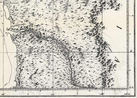
Washington State University Libraries.
Due to prior Columbia River explorations, much about the mouth of the Pacific Ocean was already known by Lewis and Clark.
Lewis Scouts Ahead
Capt Lewis concluded to proceed on by land & find if possible the white people the Indians Say is below and examine if a Bay is Situated near the mouth of this river as laid down by Vancouver in which we expect, if there is white traders to find them &c.
—William Clark
Rounding Point Ellice
at 3 oClock he Set out with 4 men Drewyer Jos. [Joseph Field] & Reu. Fields [Reubin Field] & R. Frasure [Robert Frazer], in one of our large canoes and 5 men to Set them around the point on the Sand beech. this canoe returned nearly filled with water at Dark which it receved by the waves dashing into it on its return, haveing landed Capt. Lewis & his party Safe on the Sand beech.
—William Clark
Clothing Rots Away
The rain Continues all day all wet. The rain &c. which has continued without a longer intermition than 2 hours at a time for ten days past had distroyd. the robes and rotted nearly one half of the fiew Clothes the party has, perticularley the leather Clothes,— fortunately for us we have no very Cold weather as yet and if we have Cold weather before we Can kill & Dress Skins for Clothing the bulk of the party will Suffer verry much.
—William Clark
Weather Diary
Day of the month Wind State of the Weather 14th rain a blustering rainey day
—Meriwether Lewis[3]Some abbreviations have been spelled out.


Dismal Nitch is a High Potential Historic Site along the Lewis and Clark National Historic Trail managed by the U.S. National Park Service. Interpretation is available at the Dismal Nitch Safety Rest Area on WA State Highway 401.
Notes
| ↑1 | Originally aired weekdays by Yellowstone Public Radio during the Bicentennial observance of 2003-2006. Narrated by Hal Hansen. Scripts by Whit Hansen and Ed Jacobson. Produced by Leni Holliman. © 2003 by Yellowstone Public Radio. |
|---|---|
| ↑2 | John Logan Allen, Lewis and Clark and the Image of the American Northwest (New York: Dover, 1975), pp. 96-97. |
| ↑3 | Some abbreviations have been spelled out. |