In this appendix, I list every incident I could find, in all the journals, yielding information about the expedition’s boats and boating, especially concerning the canoes. Although I mention a few exemplary river incidents from Pittsburgh to St. Charles, near St. Louis, detailed examination begins with the departure from St. Louis on 14 May 1804. The barge and two pirogues are considered when they illustrate general problems of river travel. Not every instance of a problem, such as twenty-three mentions of “wind and waves” on the upper Missouri, will be recorded. In that case, a few entries reference the frequency of the problem. There are, no doubt, omissions and mistakes. Corrections are welcome. Hereafter, in this appendix, references to the website article “The Dugout Canoes of Lewis and Clark” refer simply to “the text.”
The Continental Divide created two different stories for these canoeists: first, they designed, built, and hauled or paddled heavily loaded boats upriver, which demanded remarkable strength, stamina, and planning; then, after crossing the divide on horses, they built more canoes to paddle down to the ocean through some very fast and treacherous water, which demanded extraordinary canoeing.
As noted in the text, reading the water is a large part of canoeing (or of handling any boat on a river, whether a canoe, barge, pirogue, or raft). It is important to remember that before the expedition made their first dugouts at Fort Mandan, they had extensive river experience, including: 1,100 miles downstream on the Ohio; then up the Mississippi, 184 miles upstream on a very large river, from one to three miles wide; then up the Missouri, about 1,500 miles to Fort Mandan. There, for the first time, they made their own canoes.
Descending the Ohio in 1803, they were using—and therefore testing—various kinds of boats: the new barge and a pirogue (apparently the red pirogue) from Pittsburgh down; a worthless dugout canoe, soon discarded, and a better one, bought from settlers along the shore; perhaps a larger canoe at Wheeling; and at Fort Kaskaskia, they acquired “the best boat on the post,” the white pirogue. In those first few weeks, they had frequent trouble running aground in low water on the upper Ohio, tried sailing the barge in strong wind on 6 September 1803 and almost broke the mast, and tried to sail off a sandbar. They also negotiated Letart Falls and the Falls of the Ohio, and learned much about packing a canoe, about rain and water in the boat soaking gear, and about handling upstream winds. Going up the Mississippi 184 miles, they faced major current in the Father of Waters, and had to cross the river to use eddies below the points of land. At Wood River for the winter, they saw many Indian and settler canoes, and also used “the Bark Canoo” (Clark, 6 December 1803). They often crossed the Mississippi to St. Louis, in a variety of vessels. And, as noted in the text, Clark already had extensive canoe experience, including down the Ohio and Mississippi rivers to New Orleans in a solo canoe, a few years before the expedition. In all these boats, they were learning to read water, to use eddies, to handle cross-currents, navigate rapids, and generally manage boats both up and down rivers of diverse size and speed—therefore, they could begin to form opinions on what kind of boats they would make at Fort Mandan.
While we often think the real adventure began at St. Charles, at the edge of the settlements, there is no doubt that their river experience was already extensive, with over 1,500 miles of boating from Pittsburgh through areas rich with settlers, Indians, and canoes, before they ascended the Missouri.
How were incidents chosen for inclusion in this appendix? Naturally, the indexes in Moulton’s edition of the journals could take me only so far; an index is based on key words, and not every river incident mentioned “canoe,” or “paddle,” or “rapids,” etc. So, in addition to beginning with the indexes for each volume, I spent several years reading all the expedition journals, looking for boating action, remarks, discussion, considering those passages carefully, and collating them by date and incident. The dates of different journalist’s entries sometimes being different for the same incident, I had at times to assign a date, often the date suggested by Lewis, Clark, or Gass.
Each journalist, fortunately, has a different first letter to his last name. References to their entries use a key (provided below) to the Moulton edition, following this formula: L2, L3, etc. = Lewis, Vols. 2, 3, etc.; C2, C3, etc. = Clark, Vols. 2, 3, etc.; O = John Ordway, Vol. 9; etc.
Each incident in the appendix is numbered in chronological order, and sometimes briefly described (years are identified in abbreviated form after first bolded listing). The authority for that date is listed first, with the page number for his journal, then all journalists bearing on that incident are listed with page numbers of their various volumes. A quotation or unique remark sometimes follows a journalist’s name. When several incidents illustrate a similar problem, I sometimes reference them by the numbers in this appendix: “see also appendix entries 57 and 72.”
When a particular incident is usefully covered by Stephen Ambrose, the fine storyteller (often summarizing other scholarship), and/or Verne Huser, in his river-wise narrative of boating incidents on the trip, I reference their pages with the first letter of their last names, “A” and “H,” in italics, to clearly distinguish them from the expedition journalists: (H: 123).
So, for instance, one complete entry:
- 27 September 1804. Trouble with the Sioux and breaking anchor. (G: 47, O: 70–71, C3: 121, 123–24, H: 145)
Translation of the parenthesis in this entry: Gass: page 47; Ordway: pages 70–71; Clark: Volume 3 of Moulton edition, pages 121, 123–24; and finally, Huser (italics): page 145.
Key
L = Meriwether Lewis, Vols. 2–8
C = William Clark, Vols. 2–8
O = John Ordway, Vol. 9
F = Charles Floyd, Vol. 9
G= Patrick Gass, Vol. 10
W = Joseph Whitehouse, Vol. 11
And also:
A= Stephen Ambrose
H= Verne Huser
Pittsburgh to St. Charles
- 1803 30 August–3 September 1803. They ran aground many times, pushing, unloading, seeking help from settlers ashore. (L2: 65–70; for Ohio to Wood River narratives, see H: 76–84; A: 108–33)
- 4 September 1803. Red pirogue stuck; Lewis bought a bad canoe. (L2: 71)
- 5 September 1803. Canoes flooded by night rain; gear wet. (L2: 72)
- 6 September 1803. Sailing the barge, a sudden wind broke the boom, almost the mast. Boat stuck, they hoisted sail trying to get off, and then fetched oxen. (L2: 73)
- 18 September 1803. Letart rapids. (L2: 84)
- 18 September–11 November 1803. Gap in journals, including descent of Ohio Falls with a pilot, near Clark’s home. (See Moulton note, Vol. 2: 85)
Mississippi River
- 14 November 1803. They reached the Mississippi on day forty-five. (L2: 86)
- 14 November 1803–12 December 1803. They ascended the Mississippi from the Ohio to the Wood River, about 184 miles upstream. (L2: 86–131) There were no outstanding boating incidents, but they were learning to ascend a very large river, often in high wind, crossing to eddies, working up and around points of land, testing especially the new fifty-five-foot barge going upstream. They worked hard to make about ten miles a day, and almost doubled their crew to handle the barge. They saw boats of all kinds, including many canoes, European and Indian, dugout and bark. Clark watched as three Potowautomi Indians “in a Small Canoo Came across when the waves was so high & wind blowing with violence that I expected their Canoo would Certounly fill with water or turn over, but to my astonishment found on their landing that they were all Drunk and their Canoo had not received any water.” (C2: 131)
- 12–14 December 1803–May 1804. At Wood River, they spent five months at Camp Dubois, considering their boats and strategies for ascending another large river—the Missouri. That winter included many crossings to St. Louis and back. Clark: “Set out . . . at 7 oClock in a Canoo with Cap Lewis my servant york and one man at 1/2 past 10 arrived at St Louis, Dressed & Dined with Capt Stoddard, & about 50 Gentlemen, a Ball succeeded, which lasted untill 9 oClock on Sunday no business today.” (April 7: C2: 193) Note: a three-and-a-half-hour paddle across the mile-wide Mississippi, at night, with four men in one canoe, is serious boating.
St. Charles to the Knife River Villages
The barge and two pirogues
- 1804
15 May 1804. The barge was stern heavy; on logs three times on their second day. Lewis says they should “load their vessels heavyest in the bow” when ascending. (L2: 229–30) Then, if the boat strikes the bottom in shallow water, the bow hitting first, the boat will not turn sideways to the current, which could tip it over. The boat will remain pointed upstream. The same principles apply to pirogues and canoes, and of course the tactic is reversed when descending: the heaviest end is always upstream. (See also H: 145) - 24 May 1804. Gass: The barge “nearly upset.” (G: 9; see also H: 145, 121)
- 4 June 1804. They broke a mast near shore. (G: 12)
- 5 June 1804. Gass: “We met two Frenchmen [coming downriver] in two canoes laden with peltry.” (G: 12)
- 8 June 1804. Gass: “. . . we met four canoes loaded with fur and peltry.” (G: 12)
- 9 June 1804. The stern of the barge struck and the bow swung (still stern heavy). (G: 13, H: 146)
- 12 June 1804. Gass: “. . . we met five periogues loaded with fur and peltry from the Sioux . . . We remained with the people to whom these periogues belonged all night; and got from them an old Frenchman.” (G: 13) That was Pierre Dorian, the translator. Note: unlike Lewis, Gass seems to distinguish between canoes and pirogues (for a discussion of the difference, see The Issues on this site). With so many mainly French-Canadian voyageurs coming down the river in one week (at least eleven that day, if two per boat, plus the old Frenchman, according to Gass above), any questions the expedition had about canoes or canoeing on the Missouri should have been answered long before they reached the Mandan villages.
- 14 June 1804. Fast water, with many river crossings. They were stuck on a sand bar. (W: 24)
- 16 June 1804. Whitehouse: “. . . water rolling over Quick sands in the River very violently.” Towing was possible only by “cutting the timber off the Banks” to clear a path. (W: 25) They were ascending the Missouri in the high water of mid-May to mid-June.
- 21 June 1804. Gass: They had to “warp up our boat by a rope” through a rapid, probably using trees for fixed ropes. (G: 16)
- 22 June 1804. Whitehouse: “. . . having to tow the boat [barge] it can hardly be imagined the fataigue that we underwent.” (W: 28)
- 29 June 1804. The barge stuck, swung, and was almost lost. (C2: 328) Still stern heavy.
- 5 July 1804. Ordway: “Boat turned 3 times.” (O: 21)
- 14 July 1804. Bad squall. Clark: “The Storm . . . Struck our boat . . . and would have thrown her up on the Sand Island dashed to pieces in an Instant, had not the party leeped out on the Leward Side and kept her off with the assistance of the ancker & Cable.” (C2: 377–78; see also W: 39, O: 25, G: 20, H: 146)
- 21 July 1804. Clark: They had traveled 642 miles and 68 days from Wood River. (C2: 409) That’s about ten miles a day going upriver in high water with a heavy barge.
- 28 July 1804. Whitehouse: The boat was again on a sandbar, all hands needed to prevent it from sinking. (W: 46)
Here begins volume three of the Moulton edition
- 28 August 1804. Planked pirogues? Gass: Snag and a “hole” in pirogue. (G: 32, W: 63, O: 46, H: 146) Note: they never mention a “hole” in dugouts, though smashed or leaking. This suggests that pirogues, unlike dugouts, were planked, rather than built on a dugout base. Clark: “French rund [ran] a Snag thro: their Perogue, and like to have Sunk . . .” (C3: 19)
- 4 September 1804. Barge mast broke. (O: 53)
- 12 September 1804. Shallow sand bars. (C3: 67) Ordway: “Boat wheeled Several times and creened on hir side . . . Spring out . . .” (O: 58)
- 16 September 1804. Laid by a day and balanced loads between boats. (L3: 76, A: 167)
- 21 September 1804. Clark: “. . . by the light of the moon observed that the Sand was giving away both above & beloy and would Swallow our Perogues in a few minits, ordered all hands on board and pushed off we had not got to the opposit Shore before pt. of our Camp fel into the river we proceeded on . . .” (C3: 96, fair copy 98)
- 27 September 1804. Trouble with the Sioux and breaking anchor. (G: 47, O: 70–71, C3: 121, 123–24, H: 145)
- 30 September 1804. Barge swung in wind and waves. (O: 74) Clark: “Double reafed sale.” (C3: 128) Tail wind. Boat turned with stern on log. (C3: 130) Still stern heavy.
- 1 October 1804. Sailing, missed the channel. (O: 74)
- 2 October 1804. Met Mr. Valley, French trader. (O: 75, G: 49, C3: 138–39)
- 6 October 1804. Encountered “Ricara” bull boats (probably buffalo skin on a stick frame). Wind and waves. (C3: 146–47, G: 55)
- 8 October 1804. Meeting Trader Gravelines. (C3: 148) For overviews of the busy approach to the Mandan villages, see also G: 48–60, A: 178–82.
- 13 October 1804. Landing problems—bank either too steep or too shallow. (G: 54)
- 25 October 1804. Barge couldn’t land, pirogues could. (O: 90)
- 28 October 1804. Arrived at the Mandan Villages. (G: 60, O: 93, C3: 204)
- 28 October 1804–7 April 1805. At the Mandan Villages, they had five months to plan the rest of the trip. They had ascended over 1,500 miles of the Missouri with the barge and two pirogues, and had met many French traders coming down in canoes and pirogues, as well as Mr. Valley, Gravelines, and Hugh McCracken of the Northwest Fur Company, at the Mandans. They had certainly heard many opinions on the appropriate boats for that river, and they had the winter to consider what kind of canoes they would need: size, weight, carrying capacity, hull design, etc. For a full discussion of construction and launch of the six Fort Mandan canoes, see 19th-Century Canoes.
Fort Mandan to the Great Falls
Using Two Pirogues and Six New Dugout Canoes
Here begins volume four of the Moulton edition
- 1805
7 April 1805. Setting out. (G: 77) - 8 April 1805. Wind, powder wet, and a canoe “sinking”—one of the two small “hunter” canoes, usually paddled by two men. (G: 77, O: 127, L4: 13) Note: there were almost always some men, including hunters, walking on shore as they ascended. Usually, we cannot know exactly how many men were in the boats at a given time.
- 11 April 1805. Sailing. (O: 129 ff) Followed by over a week of sailing and wind.
- 12 April 1805. Lewis mentions crossing the river for better towing. They would have used an upstream ferry, paddling upstream at about forty-five degrees across the current. The boat would move across the river quite quickly, while losing a minimum of upstream progress. Lewis discusses banks and ferrying. (L4: 24; see also A: 220) Baptiste said the Little Missouri river was not navigable. (C4: 27)
- 13 April 1806. Small canoes could not sail in strong wind. (G: 79) Lewis: Charbonneau was at the tiller in a wind incident; the white pirogue had two sails, “sqar, and spritsail . . . sudden squall . . . spritsail jibing . . . near oversetting the pirogue. . .” (L4: 29–30) A spritsail is four-sided, using an extra boom slanted back up from the mast—an internet search for Canadian canoeist Tim Anderson provides in-depth discussion and video. I am not certain that the white pirogue used both sails at once, but it’s possible, since the square sail could be ahead of the mast, the spritsail behind. Both at once would be a lot of canvas to manage in a river.
- 19 April 1805. Lewis: “The wind blew So hard . . . we dared not to venture our canoes on the river.” (L4: 53; see also C4: 94–95) Lots of wind, 18–28 April.
- 20 April 1805. Canoes taking water. (G: 81) Bank caved in, nearly filled a canoe. (L4: 55, C4: 56, O: 134)
- 22 April 1805. Lewis: Wind difficult, “even with . . . our toe lines.” (L4: 59; see also C4: 62, O: 135)
- 24 April 1805. Waves swamped canoes while landing and unloading. (L4: 65)
- 25 April 1805. They reached the mouth of the Yellowstone River. (L4: 66–67, C4: 68)
- 29 April 1805. Gass: “. . . at a good rate.” (G: 84) Apparently means sailing. Made twenty-five miles that day, upstream. (C4: 88) Sailing was a huge advantage.
- 1 May 1805. Whitehouse: “Sailed Some,” then, “wind rose So high that we were obliged to halt . . . one cannoe lay on the opposite Shore & could not cross. I and one more was in the cannoe and ware obledged to lay out all night without any blanket.” (W: 141–42) In Montana, in May! Note: “severe frost” in next entry, 3 May. Lewis: Began sailing, then in afternoon wind, waves “several feet high” stranded canoe on opposite shore. Note: only two people paddling a small canoe, and waves only several feet high endanger it. This is further evidence of heavy loads with little freeboard. (L4: 96; see also O: 141)
- 3 May 1805. Spring brings poetry from Mr. Gass: “. . . severe frost. The snow and green grass on the prairies exhibited an appearance somewhat uncommon. The cotton wood leaves are as large as dollars . . .” (G: 85)
- 4 May 1805. Red pirogue rudder broke the night before while landing. (L4: 108, C4: 110, O: 142)
- 5 May 1805. Lewis and Clark: White pirogue rudder broke on sawyer. (L4: 111, C: 114) Bank fell in on canoe as they set off. (O: 143) Two different rudders breaking in two days seems unlikely; however, both captains describe both accidents, about four pages apart.
- 6 May 1805. Lewis and Clark: Sailing. (L4: 117, C4: 119) Lewis and Clark describe three days of good sailing, 6–9 May.
- 7 May 1805. Sailing and accident. (G: 86) One canoe over. (O: 144, W: 148, L4: 121, C4: 123)
- 8 May 1805. Clark: “. . . breeze from N.E.” (C4: 127)
- 9 May 1805. Sailing. (L4: 130, C: 133)
- 10 May 1805. Violent wind; no go. (L4: 136)
- 11 May 1805. Lewis discusses falling banks in general. (L4: 139–40)
The Missouri Breaks
- 14 May 1805. Bear attack, and another incident involving Charbonneau—in the white pirogue. Both Lewis and Clark narrate the day of the bear and a famous accident in the white pirogue (151–57). Bear attack. (O: 147–48, W: 156–57, L4: 151, C4: 154–55, H: 134, A: 224) White pirogue, Charbonneau sailing, nearly turned over. (O: 148, G: 88, W: 156, L4: 152–53, 156–57, C4: 154, H: 134–35, A: 224) See Canoeing the Missouri for a day-by-day narrative and analysis of 14 May–10 June.
- 17 May 1805. Lewis: “. . . the banks were firm and shore boald [bald] which favoured the uce of the cord [tow line]. I find this method of ascending the river, when the shore . . . will permit it, the safest and most expeditious mode of traveling, except with sails in a steady and favourable breze.” (L4: 158)
- 21 May 1805. Bad windstorm at camp. (L4: 176)
- 24 May 1805. Gass: Left two canoes behind; hunters killed “some animals.” (G: 91) Whitehouse: “2 Canoes & 6 men Stayed behind . . .” (W: 166–67; see also L4: 189) Perhaps two hunters walking and two men per boat (probably the small canoes), plus a load of meat, going upstream in fast, high water. Clark: “. . . good sailing . . . Current verry rapid.” (C4: 191) We don’t know if the small boats (the least wave-worthy) were sailing that day.
- 25–26 May 1805. Lewis: On currents and “points” and tow lines and river mouths in general. (L4: 193) On 26 May, Lewis describes “using the oars mearly to pass the river in order to take advantage of the shores,” for towing. (L4: 200) One assumes this is their standard practice.
- 26 May 1805–2 June 1805. An eventful week in the Missouri Breaks. This week is filled with too many incidents to list; all are covered in Canoeing the Missouri. See all journals, 27–31 May: G: 93 ff, O: 157–59, W: 169–78, L4 and C4: 200– 42 (to the Marias); see also H: 147 (“water to armpits”) and A: 227 for narrative summaries.
- 9–10 June 1805. They cached the large red pirogue in mud at the Marias with about 1,000 pounds of food and gear. (G: 101; see also L4: 271–72)
- 12 June 1805. Ordway: Two canoes in trouble, one “near turning over.” (O: 166; see also W: 194–95, C4: 281) Current “rapid” or “strong” mentioned frequently, but not as much as wind.
- 14 June 1805. Clark: “. . . rapid . . . great difficuelty in getting the Perogue & Canoes up in safety, Canoes take in water frequently . . .” (C4: 295)
- 15 June 1805. Just below the Great Falls. Gass: “. . . the most rapid water, I ever saw any craft taken through.” (G: 102) Clark: “We can hear the falls . . . the men in the water from morning until night hauling the Cord & boats walking on Sharp rocks and round Sliperery Stones which alternately cut their feet & throw them down . . .” (C4: 297–98; see also W: 198–99, O: 167–68)
- 16–27 June 1805. Great Falls: up a side creek and portage of gear and boats up the bank onto a plain. Here one might expect a “Eureka!” passage on canoe weight (such as: six men could not carry a five-hundred-pound canoe up such a steep hill), but none exists. Suggestive passages in the portage up to the plain:
- Four canoes emptied, hauled up rapid, ferried to south shore and portage camp. (L4: 299; see also C4: 301, W: 199–200)
- Lewis: “. . . the distance [of the portage] was too great to think of transporting the canoes and baggage on the men’s shoulders.” (L4: 300) This suggests that perhaps the men could have lifted a canoe, but the “distance was too great” to transport it. Considering all passages on lifting canoes in all the journals, we can suspect that six men could lift a canoe. At 150 pounds per man, that would suggest a 900-pound canoe. Given actual circumstances on banks and footing, my guess is that 600 pounds might be a better guess. Note: the thirty-three-foot replica canoe in the videos weighs 2,400 pounds.
- Close call going up side stream. (W: 201–02; see also L4: 303)
- Used carriages to take canoes up the bank. (W: 202) Lewis: “. . . gradual ascent . . . take them [canoes] with ease.” Suggests fairly light canoes. (L4: 303)
- Portage details: canoes loaded with gear when on the truck wheels. (O: 173–78)
- 21–27 June 1805. The portage proper offers only indirect hints at canoe weights. (L4 and C4: 323–51)
- 22 June 1805. Gass: On the portage, “one canoe on a waggon loaded heavy with baggage.” They spent one day to transport one canoe, plus baggage, “all hands” involved. (G: 104; see also O: 170–78, C4: 316 ff, A: 244) Why bury the pirogue (made of planks?) unless it was much heavier than their heaviest canoe? Of course, the pirogues were larger.
- 24 June 1805. Gass: “. . . two more canoes” portaged in one day (G: 105) Also ‘sailing on land.’ (W: 210–11)
- 25 June 1805. Gass: “One went down to the hunter’s camp below Medicine river to bring him up in a canoe.” Solo paddling miles downstream, and two men bringing the canoe up, perhaps loaded with meat. (G: 106) The small “hunter” canoes were useful for errands.
- 26 June 1805. Gass: “. . . two more canoes and baggage” portaged in one day. (G: 106–07; see also W: 212)
- 27 June 1805. Last canoe brought up. Joy mitigated by hail “7 inches in circumference.” (G: 107) Ordway: “Some nearly killed . . . heads bleeding.” (O: 176)
- 29 June 1805. Flash flood, date varies. (O: 176–77, G: 108, W: 215, H: 136)
- 2 July 1805. Lewis’s sophistication: his mountain air and wind theory. (L4: 351)
- 3–5 July 1805. The “Experiment,” a frame-and-hide, or “skin boat.” Lewis: “She will be very light, more so than any vessel of her size that I ever saw.” (L4: 356) On 5 July, a definitive passage on their need for light boats to haul heavy loads: “. . . eight men can carry her with the greatest ease; she is strong and will carry at least 8,000 lbs . . .”
Caulk. In the same passage, note his caulk: charcoal, beeswax, buffalo tallow, perhaps similar to ‘dressings’ for canoes, when pitch pines were not available. (L4: 363) See also appendix entry 116.
- 6 July 1805. Above the Great Falls, four men in two canoes went downstream (and back up) for a load of buffalo meat. (W: 219; see also L4 and C4: 364)
- 9 July 1805. The “Experiment” is finished. At first, “she lay like a perfect cork on the water. five men could carry her with the greatest ease.” (L4: 368; see also A: 246–49) This is perhaps the clearest passage in all of the journals (combined with “will carry at least 8,000 lbs,” above) on Lewis’s ideal for a boat on the expedition: lightweight, high volume; the best displacement-to-weight ratio possible.
- 9 July 1805. Gass: The “Experiment” failed for lack of pitch to caulk the seams. (G: 110) Without the pirogues now, and the “Experiment” having failed, they needed more boats. Lewis: They noted that upstream “some of the trees were large” and planned to make two canoes to supplement “the six small canoes.” (L4: 369–70) Both ponderosas and cottonwoods still grow large by the river in that area. Large ponderosas were upstream, but Clark, anxious to start out, made two canoes of the windshaken cottonwood at hand eight miles (by land) above the camp where the “Experiment” failed.
- 10 July 1805. Lewis sent eight men with four canoes to take a load of luggage upriver twenty-three miles to Clark and to return for more. NB: Two men could paddle (and line?) a fully loaded canoe upstream. (L4: 371; see also C4: 373)
- 10–13 July 1805. Canoe size. Gass: They were making new canoes, twenty-five and thirty feet long. (G: 111) But see Lewis: two canoes, twenty-five feet and thirty-three feet long by three feet wide. (L4: 379–80) Because of windshaken wood, Clark had to make canoes shorter than he wanted, but kept them as wide as possible for displacement. (O: 181–83, A: 250)
- 12 July 1805. Even empty, with only four men in three boats, the Mandan canoes going downriver for more baggage from camp were swamped by waves, a dramatic example of low freeboard and poor buoyancy. Whitehouse: “. . . wind continued to blow so hard, that one of those canoes filled, The other two took in a great deal of water.” (W: 224) Strong upstream winds against the current in that section of river make big waves.
- 13 July 1805. Knees. Gass: “. . . this evening the canoes were finished except the putting in some knees.” A much-debated issue, never solved. The “knees” appear to be some kind of thwart or buttress, perhaps from the bottom of the canoe rather than near the gunnels: a brace against warping and damage. Whether the “knees” were carved out of a remaining bulwark, or inserted and attached (suggested by “putting in”), is not completely clear. (G: 111) The purposes could have included: strengthening the hull and helping it hold its shape, creating bulwarks to aid containment of baggage (and isolate water), and creating places to sit (or kneel with a butt rest). Very probably, whatever they did was based on Alexander Mackenzie and voyageur design. They carried Mackenzie’s journals with them.
- 15 July 1805. Canoes so small and laden, some men had to walk. (C4: 385) Ordway: “[W]e loaded the 8 Canoes and could hardly find room in them for all our baggage.” (O: 184)
- 17 July 1805. Lewis: “. . . canoes so heavily loaded all persons not employed in navigating the canoes walked on shore.” (L4: 394; see also C: 396) Gass: “. . . very rapid” upriver above falls. (G: 113) Whitehouse: “. . . joined crews.” (W: 229; see also L4: 394)
- 18 July 1805. At the Dearborn River, they used cord and oars (paddles) and setting pole. (L4: 398)
- 19 July 1805. Gates of the Mountains. Deep water and cliffs to edge made landing (and towing) difficult or impossible: “Current strong . . . but may be overcome by oars.” (L4: 403; see also W: 232) No hope of using cord or pole. If Lewis’s recorded courses and distances for 19 July were also their lines of travel (note that in deep water against cliffs they could not use a cord or pole, and hence, could not hug one bank), that day they crossed the river (right bank, left, right, right, left, right, left, right) six times in thirteen and a quarter miles of river, presumably crossing to use eddies beneath every bend. (L4: 404) That is still the way to ascend that section of river, with its high cliffs to the water’s edge. Though there is now a dam above, the current is still vigorous.
- 20 July 1805. Lewis: “. . . current strong, we therefore employ the toe rope when ever the banks permit the use of it.” (L4: 406) The feet of the walkers were cut terribly by shale and prickly pears. (C4: 410)
- 21 July 1805. Near Helena, used rope and pole in shallower water. Sand Hill cranes, swans. Lewis says each man had mosquito gauze or could not do it. (L4: 411–12)
- 22 July 1805. Lewis entered eight feet of water to retrieve a shot otter: “I swam in and obtained it by diving.” At least Lewis could swim. Sacajawea says, “three forks are at no great distance,” which “cheered the sperits of the party . . .” (L4: 416–17) Men were sick, tired, with feet damaged from walking overland. (C4: 418)
- 23 July 1805. Lewis: “[W]e made great uce of our seting poles and cords the uce of both which the river and banks favored.” Most pole “sockets” were lost; stones were smooth, poles slipping. They wired gigs to pole tips. They must have been standing (to pole) most of the time in loaded canoes in “current very rapid with a number of riffles.” (L4: 419–20)
- 24 July 1805. Good general description of river and gradient. Lewis had “learned to push a tolerable good pole.” (L4: 422–423)
- 25 July 1805. Gass: “. . . some difficult rapids, but good water between them.” In 2017, still typical of this section of the Missouri river. (G: 117; see also 23–26 July: G:116–18, W: 239–241, L4: 426)
- 26 July 1805. Lewis: “. . . employ the cord and seting poles. the oars scarcely ever being used except to pass the river in order to take advantage of the shore and current.” This, and similar sentences in the Breaks section (see appendix entries 44 and 66), tell us that when ascending, they routinely ferried across the river to use eddies on the other shore, just as we would now. (L4: 429)
- 27 July 1805. Three Forks of the Missouri. (G: 118–19) The men were exhausted but Lewis makes some interesting geological remarks as he waits for Clark. (L4: 433–437) The site is now the extensive Missouri Headwaters State Park at Three Forks, Montana.
Jefferson and Beaverhead Rivers
Here begins volume five of the Moulton edition
The Jefferson River, which they next ascended, is much smaller than the Missouri (being only one of the Missouri’s three forks), but fast and willow-lined. The Jefferson did not offer the dangers of big, open water, with wind and waves and huge eddies, but the party faced a very tough haul up a fast, narrow river. They often wished they could leave the river and go overland, but they had too much gear to give up the boats, and no ready access to numerous horses. The Beaverhead, in the last fourth of their ascent to the headwaters from Three Forks, is more like a mountain stream, fast in the top half, and meandering near the bottom. The Jefferson and Beaverhead are not much changed from 1800 to now, except by grazing of the banks, dewatering for irrigation in summer, some irrigation diversion weirs, and a small dam at the top, near Camp Fortunate.
- 30 July 1805–17 August 1805. To Camp Fortunate. They ascended the ever-narrowing Jefferson and then the Beaverhead River. In these smaller waters, there was no hope of paddling across to use eddies. Increasingly, they walked on banks with the towrope, and as the stream narrowed and the willows closed in, they walked in the water all day, pulling the boats. The fast current dragged on the pants, moccasins fell apart, the stones were slippery, and the current cold. Lewis sums it up well on 4 August, near the Big Hole River: “. . . these shoals or riffles succeeded each other every 3 or four hundred yards; at those places they are obliged to drag the canoes over the stone there not being water enough to float them, and between the riffles the current is so strong that they are compelled to have cecourse [recourse] to the cord; and being unable to walk on the shore for the brush wade in the river along the shore and hawl them by the cord; this has increased the pain and labour extreemly; their feet soon get tender and soar by wading and walking over the stones.” (L5: 42; see also C5: 43, O: 192) Not to mention hauling loaded boats over numerous beaver dams.
- 30 July 1805. Lewis looked for his party’s footprints, “knowing from the appearance of the river at this place that if they had passed they would have used the cord on the side where I was.” Lewis had begun walking ahead, hoping to meet Indians with horses; preferably Sacajawea’s Lemhi Shoshone band. (L5: 15)
- 31 July 1805. Lewis: “I waited at my camp very impatiently for the arrival of Capt. Clark and party . . . river continues rapid.” When they arrive, Lewis finds that “. . . we have a lame crew just now, two with tumers or bad boils . . . one with a bad stone bruise, one with his arm accedently dislocated . . . a fifth has streigned his back by sliping and falling backwards on the gunwall of the canoe.” The latter was Gass, who doesn’t mention his injury, but thence walked with Lewis instead of pulling boats. (L5: 17–18)
- 1 August 1805. Lewis: “. . . bad rappid here the toe line of our canoe broke . . . swung on the rocks and had very nearly overset.” (L5: 28; see also O: 193) While Lewis was walking, Clark was bringing the boats up the canyon of the Jefferson, where the Lewis and Clark Caverns are now, between the Madison Valley and Cardwell.
- 2 August 1805. Lewis: The Jefferson River was “very rappid about 90 yards wide and waist deep.” (L5: 30) Later that day in a second entry, Lewis has a fine passage on beaver dams that ends, “the brush appear to be laid in no regular order yet acquires a strength by the irregularity with which they are placed by the beaver that it would puzzle the engenuity of man to give them.” (L5: 32) A glimpse into the minds of the eighteenth-century gentlemen who formed our country with a skepticism enlightened by humility: if a beaver might know more than us, perhaps a separation of powers would be wise.
The junction at the Big Hole and Ruby rivers
The events surrounding the junction of the Big Hole and Ruby rivers are complex and confusing. First, the geography: ascending the Jefferson (that is, heading south), one finds the Big Hole River (Lewis called it the “Wisdom”) entering from the right (the west), about a half mile below the present town of Twin Bridges. Just upstream of Twin Bridges, the Beaverhead River from the southwest meets the Ruby River from the southeast. That junction is now considered the beginning of the Jefferson. Lewis was travelling overland with Gass, Drouillard, and Charbonneau (possible interpreters), seeking contact with the Shoshones. Clark was several days behind with the main party and canoes loaded with gear. At the Big Hole, which at times has more water than the Jefferson, Lewis had to make a choice of route. He scouted up the Jefferson to the forks of the Beaverhead and Ruby, and back down overland to the Big Hole. The Ruby was too small; the Big Hole too fast and turbulent. Lewis decided that the middle fork, now called the Beaverhead, was the main stem of the Jefferson and would lead them deepest into the mountains of the Continental Divide, the headwaters of the Missouri. It also came from the southwest, more towards the Shoshone territory, as Sacajawea advised. It was a good choice.
- 3 August 1805. Lewis and companions had camped above the Big Hole river, and this day explored all three forks that combine to make the Jefferson. Clark was still toiling up the shallow, fast Jefferson. Ordway: “. . . double man the canoes and drag them over the stone and gravel.” (O: 195)
- 4 August 1805. Lewis, having seen the smaller Ruby River coming into the Jefferson from the east, walked west up the Big Hole river. He decided the fast, clear, turbulent Big Hole was not navigable, and that the smaller, calmer, and more colored Beaverhead (the middle fork) came from farther away in the mountains, and, according to Sacajawea, came from the right direction (southwest). He returned to the mouth of the Big Hole and left a note for Clark: take the middle fork, not this one. (L5: 40–43; see also Atlas Map 65, O: 196–197)
- 5 August 1805. Lewis continued overland reconnoitering, and reconfirmed the Beaverhead choice (middle fork), while Clark arrived at the Big Hole, but did not find the note (it had been posted on a green willow which a beaver had cut). Clark and crew chose the larger, faster Big Hole river, ascending with great difficulty, dragging their canoes, and spent the night about a mile upstream.
- 6 August 1805. Lewis was coming down overland when he heard whoops to his left. He headed to the Big Hole, and discovered that Drouillard had already found Clark there, at breakfast; and Drouillard had sent Clark’s party back down. On their descent of that rapid and log-jammed river, Clark’s boat capsized and two other canoes were swamped. Whitehouse was in the boat: “I was in the Stern when she swang and jumped out to prevent hir from turning over but the current took hir round So rapid that caught my leg under hir and lamed me and was near breaking my leg . . . several canoes ran fast &c. one of the large canoes took in water and was near filling.” (W: 257; see also O: 97) Lewis summarizes well (from other reports): “[O]ne of their canoes had just overset and all the baggage wet, the medicine box among other articles and several articles lost a shot pouch and horn with all the implements for one rifle lost . . . two other canoes had filled with water and wet their cargos completely.” Clark does not mention that it was his canoe. Lewis was not there but of course he talked to Clark and others; he reports: “Whitehouse had been thrown out of one of the canoes as she swing in a rapid current and the canoe had rubed him and pressed him to the bottom as she passed over him and had the water been 2 inches shallower must inevitably have crushed him to death.” If true, it is evidence, once again, of very heavily laden boats. (L5: 52–53; see also G: 122, C5: 42–55: Big Hole area in general; O: 196–7, H: 88)
A difficult run. This downriver run of a mile or so through the cottonwood flats of the lower Big Hole River was their first significant downriver experience since the Ohio, and one of their most tricky runs on the trip. I have canoed that section of river several times; it is not much changed since 1805, at least not in early summer before ranch irrigation takes water out. The deadfall and sweepers at many sharp bends are often invisible until you are twenty yards away. Overhanging branches and fallen limbs restrict your options.
First, it is noteworthy that they were paddling, not lining down along the bank or in the shallow stream. Paddling down—or, ‘running the river’—is sometimes necessary when a lot of deadfall along the bank makes walking and lining very difficult (common to the lower Big Hole river), but it also shows considerable confidence.
Second, in heavily loaded canoes they were probably backpaddling in that section of the river, which is only about thirty yards wide; the main current can be only five to ten feet wide. You slow the boat down to stay to the inside of each bend and to avoid downed trees at the outside of bends. Backpaddling is not necessarily going backwards, but may be used to avoid gaining speed as you approach a bend (a canoe is actually sliding downhill as it floats on a river, and centrifugal force pushes it towards the outside of a bend). Backpaddling and draw strokes can give you time to position the boat on the inside of the bend and to float around obstacles. It is instinctive when you are going too fast in a small stream and there are dangers ahead. They were in conditions that demanded very sophisticated canoeing in cramped, fast water.
- 7 August 1805. They had consumed enough supplies to consolidate loads and hide a canoe in the willows for the return, “one of the Small canoes.” The meandering Beaverhead slowed them down; oxbow turns can add many miles. Whitehouse: “. . . passed 60 points [meaning bends] this day.” (W: 258; see also L5: 55, O: 197–98) See also L5: 58: “very crooked many short bends . . .”
- 8 August 1805. They were now ascending the shallow Beaverhead (the middle of the three forks that form the Jefferson, and considerably smaller), dragging over the riffles. Lewis: “. . . used the setting poles today almost altogether.” Interesting. The banks must have been so brush-choked, with “rosebushes and briars very thick,” that they could not line. (L5: 59) The Beaverhead is smaller and slower than the Jefferson; the Beaverhead meanders, ankle-to-knee deep, very even-tempered. Poling would also have kept them out of the cold water. Farther upriver, on 10 August, Gass mentions that the Beaverhead (they called it the Jefferson) was “in some places so shallow, that we were obliged to get into the water and drag the canoes along.” (G: 124) That implies poling as a means of staying out of the water, with banks too brushy for lining. They got out of the boat to lighten it, and to lift by the gunnels and drag. During the day, Sacajawea recognized the Beaverhead Rock, and said they were nearing her people. (L5: 59)
- 9–10 August 1805. Lewis and companions traveled overland up the Beaverhead past Blacktail creek (present Dillon), up the canyon [the Beaverhead Canyon Gateway] above Barrett’s, past present Grasshopper Creek and into the basin of Horse Prairie, where they would leave the boats at Camp Fortunate. There, Lewis was ringed by the Continental Divide, with an easy walking route across. He makes a very astute observation about the terrain: “I do not believe that the world can furnish the example of a river running to the extent which the Missouri and Jefferson’s rivers do through such a mountainous country and at the same time so navigable as they are.” (L5: 65) It’s true; the rivers head near 7,000 feet, ringed by fairly gentle peaks of 10,500 feet with passes at 7,000 to 9,000 feet. It strikes one as horse country, not ‘alpine.’ As Clark notes on 11August, near Dillon, they were now 3,000 miles by water from the mouth of the Missouri. If you have ever tried to take a canoe ten miles upriver, by paddle, pole, line, or drag, you may appreciate their achievement in ascending 3,000 miles. Including the Mississippi down to New Orleans, the Missouri–Mississippi is the second longest river system in the world (the Nile is first).
- 11–16 August 1805. Clark’s party was toiling upriver, through the fast water in the canyon above Dillon. Ordway narrates: on 11 August, “some of these rapids is deep and dangerous to pass up.” And then, in the upper Beaverhead, still a blue-ribbon trout stream, on 12 August, “caught a number of fine Trout this several days.” For six more days they worked upstream, passing “Several bad rapids . . . some holes where we caught a number of trout . . . oblidged to hall the large canoes the most of the time.” (O: 201–03) This may mean pulling them up by the gunnels, if it was too shallow to line from the bank. (See also 4 August: O: 195)
- 17 August 1805. They arrived at the junction of the Ruby and Horse Prairie creeks, the head of the Beaverhead/Jefferson/Missouri system, and brought their canoes to a halt. Ordway says, “the natives rode back & forth the Shore to See us come up with the canoes. we halled the Canoes over a great nomber of Shole places and arived at Capt. Lewis Camp . . .” (O: 204) Those were the Shoshone Indians, including Sacajawea’s brother, with horses.
Down the Columbia Drainage
Scouting the Salmon River
They traveled across the very easy, grassy divide, by horse, with Sacajawea’s relatives, to the Shoshone camp near the Salmon River. From there they would leave rivers for over a month, traveling by horse with Shoshone guides over the Lost Trail divide and down the Bitterroot river, then up Lolo pass and down the Clearwater drainage to a Nez Perce camp near Orofino, Idaho.
But first, back at Sacajawea’s Shoshone camp in Idaho, Clark explored the Salmon River. His rejection of that route deserves some attention.
The Salmon offered a direct route to the Snake River. I have canoed and rafted it many times, and it would have saved them from the worst privations of their trip: on horses in deep snow on the ridges above the Lochsa and Clearwater rivers—a dangerous trip that took nearly six weeks—to a camp with the Nez Perce on the Clearwater. On the other hand, by descending the Salmon on boats or rafts, they might have reached the Snake in ten days, and the Pacific in September.
Clark certainly considered it. After sending men out to “search for timber to make canoes for descending the Columbia,” Clark scouted a few miles of the Salmon River Gorge (tributary to the Snake and Columbia), and ruled it out as impassable. (18 August, G: 127; O: 207) The Indians agreed, and said it was worse farther down. The pioneer runners of the main Salmon in the 1930s used medium-sized Kentucky flatboats with sweep oars at each end, boats that would have been familiar to Clark, and easy to build. I have canoed the Salmon Gorge, and it is not that difficult in the big water of early summer. However, I descended the Salmon in low water this past September (2018) and was surprised to find the Salmon much more difficult in low water than in high. The raft guides agreed.
Clark, a very experienced boater, clearly rejected the Salmon option: “entirely impassable . . . mountains . . . prevent a possibility of a portage . . . [Indians say that below] the water runs with great violence from one rock to the other on each side foaming and roreing” and the mountains and cliffs would prevent escape from the gorge. (C5: 155-6) Also, they saw “no game of any kind,” which the Indians corroborated. (W: 289)
On the other hand, even without game, there were a lot of fish. And, although “The Indians say” that the water below is fierce, consider that these are Shoshones, mounted Plains Indians. They are at the western edge of their range, where the Salmon River descends into its gorge. If by chance Lewis and Clark had met up with Nez Perce river (as well as Plains) Indians, instead of Shoshones, they might have heard a different story. In addition, the Salmon would have met Jefferson’s request to explore the most direct water route to the Pacific.
I have discussed this with Verne Huser, the author of Lewis and Clark on the River and a professional Salmon river raft guide. Huser agrees with me, that the Salmon in low water (2,000 cfs) is “dangerously rocky.” (H: 125-6)
A decision to launch onto an unknown whitewater river, on a route not recommended by local Indians, in a gorge with questionable walking out, with many men who could not swim and few as experienced in boating as Clark, would have risked disaster, whereas the Indian trail over Lolo pass seemed to risk only delay and hardship. Moreover, they had been assured by the Shoshone that the Lolo pass walking route to the Clearwater would only be ‘ten sleeps’ (it turned out to be closer to thirty) and therefore they must have felt no need to take a chance on the Salmon.
They would begin to make their next canoes 27 September, on the Clearwater branch of the Snake and Columbia, about thirty miles west of the Continental Divide. Those canoes would reach the Pacific.
The Boats at Clearwater Canoe Camp
Indian Canoes in Virginia
by John White, c. 1590
Theodor de Bry colored engraving (circa 1590) after John White painting. From the collections at The Mariners’ Museum, Newport News, Va.
- 25 September 1805. They had made their way over the divide, with great difficulty, on foot and with horses in deep snow. They arrived at the Clearwater River, near present Orofino, Idaho, to build new canoes. They stayed near Nez Perce Indians, who were friendly with the Shoshones. Clark was looking at trees for dugouts, and at Nez Perce canoes made for this river: “[T]wo Canoes Came up loaded with the furnitur & provisions of 2 families, those Canoes are long Stedy and without much rake.” (C5: 233) That means a bow fairly near the vertical, versus a long, shallow incline. The remark shows Clark’s sophisticated awareness of hull design.
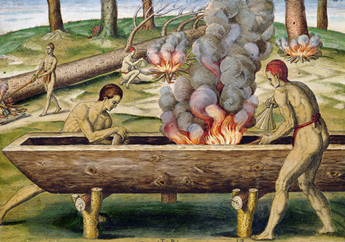
- 25 September 1805–5 October 1805. They sought good trees for dugouts, finding “fine timber” in Ponderosa pines. (C5: 233; see also W: 335, O: 229–234) Because many men were sick, and their axes were small, they used “the Indian method of burning out the canoes.” (G: 150) The Moulton note for Gass’s entry is correct: Ambrose was certainly wrong in thinking the canoe was upside down over a fire. After the top third of a horizontal log was cut off; a line of fire was laid down the middle of the remaining log; the fire gradually sank downward. Periodically, the insides were caked with wet mud to maintain the right thickness; charcoaled wood was chipped out of the bottom and new fires were laid. Whitehouse says they “built fires on Several of the canoes . . .” (W: 336)
This method was depicted in one of John White’s illustrations of Indian canoes in Virginia, in the book Jefferson owned. Theodor de Bry based the engraving above on White’s painting; the engraving offers greater detail. Lewis, living in Jefferson’s house, may well have seen the book. Clark describes: “Burning out the hotter [hollow?] of our canoes.” (C5: 244) He does not identify the method as Indian, or as new to him. (See also A: 301, H: 92–97, 128ff, 138–140)
This period from 25 September to 5 October was full of interactions with Nez Perce in canoes, and all the journalists were clearly interested in their first glimpses of native canoeing west of the Rockies. Clark, on foot, mentions that “one of the Indian Canoes with 2 men with Poles Set out from the forks at the Same time I did and arrived [upstream!] at our Camp on the Island within 15 minits of the Same time I did, notwithstanding 3 rapids which they had to draw the Canoe thro’ in the distance.” (C5: 233) Though the river might be a straighter route than walking, poling and dragging upstream through three rapids and averaging nearly a walking pace (three to four miles an hour) is indeed remarkable. On 4 October, Whitehouse says some canoes were “ready to dress and finish off.” (W: 337) This probably refers to smoothing the hulls, and applying some kind of waterproof paste. Two different operations are suggested, but the terms are not really clear.
Canoe terms. This period of intense canoe-making at the Nez Perce camp—five canoes, because now they had no pirogues for support, and they were descending difficult rivers—is a good time to consider what we do and do not know about their making, repairing, and ‘finishing’ of carved dugouts. A number of words in the journals are associated with these issues: for example, in the construction phase, “nails” and “knees” are cited, and in finishing off, “caulk,” “dressing,” “pitch,” and “finish” are used.
On this topic, Moulton’s index is remarkably limited; probably he was not that interested in canoe design and construction. “Caulk,” Moulton’s index tells us, is mentioned (but not defined) by Ordway four times, and “nails” have six references in his index, but “knees” appears in Moulton’s index only as a medical reference to the knee joint, and “dress” refers only to hunting or shirts; “finish” and “thwarts” do not appear in his index at all, although they appear in the journal texts. Since “thwarts” are mentioned by Lewis only in reference to an Ohio River canoe, we can assume that the word was current, and its absence in the journals after the Mandans might mean that, indeed, their canoes had no thwarts. However, both Lewis and Clark use the terms “cross bars” or “horizontal bars” fitted “into sections of the boat.” (L4: 336) Also, at Fort Clatsop, Lewis and Clark say two Indian canoes “wanted some knees to strengthen them.” (L6: 429) See the discussion of “knees” in appendix entry 122. Until we know just what “knees” were, we cannot be sure if the expedition regularly had gunnel to gunnel separators—thwarts or knees—or not.
Moulton aside, our best authority for guessing at these terms is Mackenzie, the contemporary explorer, author, and builder of bark and dugout canoes in Canada whose two-volume book Jefferson had ordered from London the moment it was printed, and which Lewis had read in Jefferson’s household and had brought with them on the journey. Lewis and Clark tell us that pitch pines were important, and Mackenzie describes various mixtures of pitch and ground-up campfire charcoal as a caulk. Whether “finishing” refers to final smoothing with drawknives, files, rasps, which we know they carried with them (sandpaper not yet invented), or to a fat or sap paste rubbed in to make the surface more water repellent and smooth, or both, we do not know.
So, when on 4 October Whitehouse tells us their canoes were “ready to dress and finish off,” and also that they had bought a “fat dog” from the Nez Perce to eat, we might guess that some fat rendered over the campfire was captured for a finishing paste. (W: 337) Man’s best friend.
This understanding of smoothing and then rubbing with a paste is corroborated when they repair canoes on the Columbia, 26 October (see appendix entry 136).
These terms are mentioned in the following appendix entry numbers:
Braces: 88, 122, 202, 213.
Thwarts: 88, 184, 202.
Knees: 88, 122, 184, 202.
Pitch: 81, 84, 122, 136, 160, 163, 170, 192, 201.
Caulk: 81, 84, 122.
Dressing: 81, 116, 136.
Finish: 88, 116, 119, 122, 136.These and related terms can be searched in the expedition journals online.
- 5 October 1805. Clark: “[Launched] two canoes today . . . one proved a little leakey . . . the other a verry good one.” (C5: 246)
- 5 October 1805–2 November 1805. This month from the Nez Perce camp through the falls of the Columbia contains the most intense downriver canoeing on the expedition, and will be examined in some detail.
- 6 October 1805. Clark: “. . . all the canoes finished.” (C5: 248) Gass gives an informative overview of the fleet: “. . . we put the last of our canoes into the water; loaded them, and found that they carried all our baggage with convenience.” Surely this means that the canoes were not as dangerously low in the water as they were when leaving Fort Mandan. “We had four large ones; and one small one to look ahead.” (G: 151) This implies that on their first downstream leg of the journey, they were aware of the need for a scout canoe to lead the way through rapids.
- 7 October 1805. The rapids in that section of the Clearwater are still very bony in October, and the rocks can be quite sharp: reefs of rock strata on edge, versus smooth river boulders. They had trouble right away. Clark: “. . . passed 10 rapids which wer danjerous . . . the canoe in which I was Struck a rock and Sprung a leak in the 3rd rapid.” In the first (raw) copy Clark mentions “one Canoe that in which I went in front Sprung a Leak in passing the third rapid.” (C5: 249) So, we know that Captain Clark, the experienced river man, was in the small, lead (“front”) canoe “to look ahead” and choose the lines through the rapids. (G: 151) Springing a leak from hitting one rock suggests a normal two-inch to three-inch thick bottom, and not six-inch to seven-inch. Gass: “We therefore halted and mended her.” (G: 151) Just how they mended a dugout, leaking enough that Clark’s precious cargo is transferred “in an other canoe for fear of gitting the Instruments &c. wet,” is not narrated. (W: 340) Clark says they “mended a Small leake which we discovered in a thin place in her Side.” (C5: 250) Ah, perhaps approaching Chittendon’s formula of one-inch sides for Missouri River dugouts; see The Issues. If small enough, the repair might have been with a paste, some mixture of fat or sap and ground charcoal, similar to MacKenzie’s; see What Did Lewis Want? on this site and appendix entry 116 on “Canoe terms.”
Whitehouse gives an unusually full description of the canoeing difficulties in those first days on the Clearwater. On 7 October (raw copy): “[W]e put the other three canoes in to the River . . . and loaded them. about 3 oClock P.m. we Set out on our way to descend the River . . . we proceeded on . . .” And (fair copy): “. . . crossed a number of bad rapids, where our Canoes got fast, & obliged us to get out in the Water (that was cold) and hawl them off . . . The Rapids were very frequent & Shoal [reefs and ledges versus boulders], the bottom of the River rockey, and the hills making close in to the River on both sides . . . We also found, that in some of the Rapids where we had plenty of water for our Canoes to pass, that the Waves ran so high that our Canoes took in a great deal of water, & we struck several Rocks, in passing over them, but the Rapidity of the stream forced us over them.” (W:339–40)
- 8 October 1805. Another tough day on the river. Clark: “. . . passed 15 rapids four Islands and a Creek on the Stard Side at 16 miles just below which one canoe in which Serjt. Gass was Stearing and was nearle turning over, She Sprung a leak or Split open on one Side and Bottom filled with water & sunk on the rapid, the men, Several of which Could not Swim hung on to the Canoe, I had one of the other Canoes unloaded & with the assistance of our Small Canoe [Clark’s] and one Indian Canoe took out everything & (got) towed the empty Canoe on Shore, one man Tompson a little hurt . . .” (C5: 251)
Gass, at the helm of that canoe: “In the evening, in passing through a rapid, I had my canoe stove, and she sunk. Fortunately the water was not more than waist-deep, so our lives and baggage were saved, though the latter was wet. We halted and encamped here to repair the canoe . . .” (G: 151)
Again, Whitehouse has interesting details: “. . . as we were descending a rockey rapids at the foot of an Island on which was Some Indian Camps, one of the canoes Struck a rock and wheled round then Struck again and cracked the canoe and was near Spliting hir in too . . . throwed the Stearsman over board, who with difficulty got to the canoe again, but She soon filled with water, and hang on the rocks in a doleful Situation. Some of the men on board could not Swim, and them that could had no chance for the waves and rocks. an Indian went in a Small canoe to their assistance. our little canoe [Clark’s] went also . . .” (W: 341–42; nearly identical narration in O: 235)
Note two discrepancies here. First, Gass (he was in the boat) says the water was fortunately only waist-deep, while Whitehouse sees “no chance” even for swimmers because of “the waves and rocks.” A difference in personality? Maybe, but if you can’t hold onto the boat, waist-deep in fast water with rocks is pretty dangerous. Second, the Moulton note identifies the “Stearsman” as “Perhaps Thompson” (W: 343), but it seems to me that Clark and Gass (“my canoe”) have both indicated that Gass was steering.
As Moulton notes, we know where this camp is (near Spalding, Idaho). (W: 343) The rapids would now be rated Class II to III in difficulty. This rescue operation was an excellent rehearsal for the much more difficult mid-river rescue on the Snake a week later, treated in detail in the text.
- 9 October 1805. In camp repairing canoes. Some of the only glimpses, in all the journals, of their repair methods, come from Clark’s entry here: Some men “collect rosin.” The woods there have Ponderosa, a pitch-pine. Clark: “In examoning our canoe found that by putting Knees & Strong peces pined [probably ‘pinned’]to her Sides and bottom &c. She Could be made fit for Service in by the time the goods dried, Set 4 men to work at her, . . . others to collect rosin, at 1 oClock She was finished Stronger than ever.” And then ‘pinned’: from other passages, we know that they had nails and used them in canoes, and they pulled nails from their abandoned canoes on the way back (11 July 1806, appendix entry 184). They had to stay the night, however, to dry out the wet cargo. (C5: 252)
Canoe design. Moulton’s note on the ambiguity of “peces pined” brings up the interesting issue: exactly how was the boat repaired? My guess is that “Knees & Strong peces” refer to added wooden braces, and that such additions could be both ‘pinned’—they certainly had drills and probably dowels, or could make them, as well as nails—and also the additions and pins would be ‘primed’ with pitch to make them more secure and waterproof. “Knees” now commonly refers to rounded triangular braces inside the hull of a boat. Whitehouse: “We caulked the canoe that was stove.” (W: 345) Probably with a pitch mixture. Ordway: “[W]e got the canoe repaired in the evening . . .” (O: 235) Gass: “. . . repaired our canoe.” (G: 152) If my guess is correct, that braces were shaped and added, it bolsters the argument that the canoes were fairly thin (a standard one-inch to three-inch thickness) and that a damaged hull could lose its shape, as well as leak. See appendix entry 116 on “Canoe terms.”
Clark: “Two Indians come up in a Canoe, who means to accompany us to the Great rapids.” The falls of the lower Columbia. (C5: 255)
- 10 October 1805. Another difficult day. Clark: “. . . passed 2 islands and two bad rapids . . . a verry bad riffle.” Here Clark adds details of how they ran the river, details identical to contemporary canoeing practice: “[W]e landed . . . on the Lard Side to view the riffle . . . after view’g this riffle two Canoes were taken over verry well; the third Stuck on a rock which took us an hour to get her off.” This description suggests that the first two canoes stopped below (eddied out) and waited for the others to come down safely. Reference to “a Small Split in her Side which was repared in a Short time” again suggests fairly thin sides. (C5: 255) Whitehouse describes even more rapids downriver: “Some verry bad rapids which were Shallow. we had to wade in Several rapids to hale [haul] the canoes over.” (W: 345–46; see also G: 152, O: 236) It is interesting that they apparently did not line boats down rapids shallow enough to wade. However, we know that they were behind schedule. Jumping out and jogging down a shallow rapid holding onto a gunnel is faster than lining.
They camped at the junction where the Clearwater meets the Snake. The Snake rises south of the Yellowstone Plateau, and runs west then north. It drains an enormous desert area (most of Idaho), but carries a disproportionately small amount of water. The expedition had descended the Clearwater, a small, rocky tributary to a much larger river (the Snake below the entrance of the Salmon), which had Class IV rapids (before it was dammed), large waves, and, in October, large rocks showing. They were anxious to reach the coast.
- 11 October 1805. They ran a number of rapids, “where the waves roled high, “and “two Indians accompy. us in a Small canoe.” (O: 237) Gass: “Two of the Flathead chiefs remained on board with us, and two of their men went with the stranger [the Indian of “another nation”] in a small canoe, and acted as pilots or guides.” (G: 154) So, the small Indian canoe ran through each rapid first, showing the ‘line’ on the river the Indians knew well. That practice would be important the next day.
- 12–13 October 1805. After “Swift water” and rapids, “Several of them very bad,” they came to one that halted the expedition. Part of the party ran the rapids on 12 October 1805, the others the morning of 13 October. Clark: “. . . came to at the head of one (at 30 miles) on the Stard. Side to view it before we attemptd To dsend through it. The Indians had told us was verry bad—we found [it] long and dangerous about 2 miles in length, and maney turns necessary to Stear Clare of the rocks, which appeared to be in every direction.” A classic description of a long rock garden. Once again, they followed standard, modern canoe practice. The two new Indians who knew the river, in their small (maneuverable) canoe, and Clark, with several men in the small lead canoe, pulled out their canoes and scouted from the bank, the Indians no doubt pointing the route. “The Indians went through & our Small Canoe followed them.” (C5: 265) The rest of the party camped for the night above the rapids. The next morning, “all the men which could not Swim went by land and carried Some rifles & instruments &c.” (W: 350) That kept the non-swimmers and equipment safe, and also lightened the canoes for difficult maneuvering.
You can bet that in the evening before, or early the next morning, someone of the party who had run the rapids walked upstream along the bank to point out the route to the upper party, and discuss particular difficulties. They would have stood on the bank pointing and talking (no no, move left below that rock, the black one, and stay this side of the monster rock . . . Which one? . . . etc.), discussing rapids a hundred yards away and two miles long. Finally, of course, in a two-mile rapid each boat would be improvising, making its own split-second decisions. One boat moved sideways better than another; one crew was better at backpaddling or drawing; one steersman was three feet left of the best line, and realized he couldn’t get right of the next rock, and would go left instead. Long, difficult rapids are scouted and planned . . . then improvised.
All the journalists write something interesting on these rapids. Gass: “. . . we then proceeded with two canoes at a time . . . and in about two hours got all over safe.” (G: 154) Clark agrees. Ordway says “one canoe at a time.” (O: 238) Two canoes at a time limits rescue needs: no more than two boats and fewer men in trouble on each run; it also allows a ‘good’ boat (better craft, or steersman, or crew), to lead a less skilled boat through. After noting the safe passage, Clark adds, “We Should make more portages if the Season was not So far advanced and time precious with us.” (C5: 266) Ordway, discussing the same rapid: they had “delayed untill about 10 oClock” that morning. (O: 238) Very probably to scout the rapid, the most difficult they had faced. After they all came through safely, they quickly came to another “bad rapid” and then “a long bad rapid . . . in which the water is Confined in a Chanel of about 20 yards [narrow!] between rugid rocks for the distance of a mile and a half and a rapid rockey Channel for 2 miles above.” They had entered the volcanic Coast Range, and though these rapids are now long buried under dam pools, the descriptions suggest the long ledges and drops, and sharp rocks, of the Columbia plateau lava fields. Clark muses, “This must be a verry bad place in high water.” (C5: 268) Even in low water, the Snake confined to twenty yards—or fifty—would be frightening. Whitehouse says fifteen yards wide, and “the canoes ran down this channel Swifter than any horse could run.” (W: 351) Actually, thirty miles an hour in a pool and drop rapid is very possible. One can find numerous pictures of rafters with hair blowing wildly back in Grand Canyon rapids.
Clark notes the abundant Indian fishing camps and the remains of “their fish for ages past,” from salmon runs, now gone. (C5: 268) Gass says they “passed more bad rapids, but got through safe.” (G: 154)
- 14 October 1805. This is the day that Ordway’s canoe was stuck on a rock in the middle of the river and filled with water. Four men got out onto the rock, baggage washed out, the lightened canoe “went off of a sudden,” and the men had to be rescued, mid-river, by another canoe, “Steming the Swift Current to the relief of the men on the rock.” (C5: 272) This entire incident, important for assessing their canoeing prowess, is treated fully in What Did Lewis Want?. Ordway was the steersman. (O: 238, C: 271, G: 155, W: 352)
Whitehouse also says that in the morning, before Ordway’s incident, they had descended a “verry bad rockey rapid the worst we have passd in this River. three of the canoes ran fast on a Solid rock at the head of the rapids two on at a time and was in great dangr. of being lost. one Struck a rock in the middle of the rapids and luckily escaped being Stove.” (W: 352) Clark also, in his second (fair) copy only, refers to this earlier incident.
It seems this section of the Snake had many difficult Class III to IV rapids. In a conversation with the author, historian Bill Lang calculated that in October of 1805, the Snake below the Salmon and Clearwater would have been running about 13,000 to 15,000 cfs.
- 15 October 1805. Gass narrates a quiet day, after drying baggage all morning: “This river in general is very handsome, except at the rapids, where it is risking both life and property to pass.” But even those rapids, he continues, “may add to its beauty, by interposing variety and scenes of romantick grandeur . . .” (G: 155) Gass seems to be the Romantic aesthete of the crew, with Lewis. Clark, however, was in a different mood: “[P]assed eleven Island and Seven rapids to day. Several of the rapids verry bad and dificuelt to pass.” His entry is absorbed with the rapid (Fishhook rapids) that they had reached in the evening, and would attempt the next morning: “[N]arrows for 3 miles where the Clifts of rocks juted to the river on each Side compressing the water of the river through a narrow chanel . . . [below a small pool is] a bad dificuelt and dangerous rapid to pass.” At the top of the rapid they encountered “the three Indians who had Polited us thro the rapids from the forks. those people with our 2 Chiefs had proceeded on to this place where they thought proper to delay for us to warn us of the difficulties of this rapid.” (C5: 275) Pretty nice of them.
They would run the rapids the next day.
- 16 October 1805. Clark is very specific about their protocol: we “determined to run the rapids, put our Indian guide in front our Small Canoe next and the other four following each other, the canoes all passed over Safe except the rear Canoe which run fast on a rock at the lower part of the Rapids, with the early assistance of the other Canoes & the Indians, who was extreamly ellert every thing was taken out and the Canoe got off . . .” (C5: 277)
This was another mid-river rescue (the one on 14 October was good practice). Whitehouse participated: “One of our Canoes struck on a rock . . . & swung round and remained fast . . . till the Canoe that I was in came to their assistance & a small Canoe [Clark’s] belonging to our party. The Men from the two Canoes got the load out of the Canoe, & got her off the rock & to the shore. We got the canoes loaded again & continued on our Voyage.” (W: 355)
Gass adds a further detail: one canoe was stuck on a rock, “but by unloading another canoe and sending it to her assistance, we got all safe to land . . .” (G: 155–56) Unfortunately, the ‘rear’ boat had gotten stuck. Men were stranded on a rock and the others first unloaded a rescue boat, pulled it upstream, and ferried across, “Steming the Swift Current” to the boat and rock, as in the rescue on 14 October. (C5: 272) In this instance, they have also unloaded the stuck boat. These are very difficult canoeing maneuvers in fast water.
Later, “in the afternoon we Came to the last bad rapid as the Indians Sign to us. we halted little above and carried Some of the baggage past by land abt. one mile then took the canoes Safe down . . .” (O: 239) There is never any mention, thus far in the journals, of lining down some of these west slope rapids by walking in the shallows or on the shore, though in a few days they would definitely ‘line down’ on the Columbia.
Gass: “Having gone 21 miles we arrived at the great Columbia river.” (G: 156) According to Whitehouse, they camped at the junction of the Snake and Columbia, near many Indians “on the same point of land . . . This whole band of Indians came in a body, Singing in their manner to our fires, Smoaked with us, & appeared friendly.” (W: 356)
On the Columbia River
- 17 October 1805. Clark in a small canoe with two of his men paddled ten miles or more up the Columbia from its junction with the Snake, seeing dead salmon everywhere (it was the fall run; the salmon die after breeding and wash downstream). There were “great numbers of Indians on the banks viewing me and 18 canoes accompanied me from the point.” They would now encounter numerous Indian coastal canoes: state-of-the-art dugouts, then and now. As Clark returned, “I was followd. by 3 canoes in which there was 20 Indians.” (C5: 288)
- 18–19 October 1805. They descended the Columbia twenty-one miles to an Indian camp “where they have 30 canoes.” On 19 October they passed some “bad rapids” with no consequence, though they stopped and scouted the second one. (G: 158; see also C5: 298) In his fair copy, Clark gives more details of scouting and running the second rapids: they took out on the left side, “as the Chanel appeared to be close under the oppd. Shore, and it would be necessary to liten our canoe.” Clark decided to walk the left bank and “derected the Small canoe to prcede down on the Lard Side to the foot of the rapid which was about 2 miles in length.” Clark waited at the foot of the rapid for “about 2 hours for the Canoes which I could See met with much dificuelty in passing down the rapid on the oposit Side . . . maney places the men were obliged to get into the water and haul the canoes over Sholes.” (C5: 304–05) Apparently, the canoes had to stick to the channel on the right to have enough water, but when the water was too difficult, the canoeists were forced into the shallows, and the men had to drag the canoes over rocks. Again, their canoeing strategies were no different from a modern expedition. That day, Clark saw Mt. Hood. They landed for the night across the river from an Indian camp, “and about thirty-six canoe loads of them came over to see us.” (G: 158)
- 20 October 1805. Clark calls Pelican Rapids “verry bad,” with huge black rocks “nearly Chokeing the river up entirely,” but none of the journalists report problems. (C5: 311)
- 21 October 1805. Scouting practices.
A very useful remark from Clark on scouting practices: they stopped to scout rapids, “which was our constant custom,” and “all who could not swim” walked around. Note: “constant.” (C:317)
They navigated five bad rapids in succession: “the river is Crowded with rocks in every direction.” (C: 317) Whitehouse is more vivid: “. . . Several verry bad rockey rapids, where the River was nearly filled with high rocks of a dark colour, and the water divided in narrow deep channels, where we ran through verry fast high waves and whorl pools below.” (W: 363) Having canoed the Grand Canyon, where canoeists lament the ‘swirlies’ at the bottom of rapids—eddies and whirlpools constantly changing, moving, forming, and dissipating in seconds so that there is no ‘line’ between or around them—I can hardly imagine the lower undammed Columbia, at ten or twenty times the volume of the Grand Canyon, full of rocks and fast channels leading to “whorl pools below.” That was very tricky canoeing.
- 22–23 October 1805. The Great Falls (Celilo Falls) of the Columbia. The complex navigation in and around the Falls, floating and portaging, is well covered by Moulton in the journals (including Clark’s map of the falls). We will note only unusual canoeing details. They portaged their gear, with the help of Indian horses, and could take canoes part way down a channel on the opposite side. (H: 140)
On 23 October, Clark and others give clear descriptions of lining down. Ordway: “. . . took all the canoes across the River and halled them about a quarter of a mile over the rocks.” (O: 243) This suggests lighter canoes. Gass: “. . . took the canoes over to the south side . . . Here we had to drag them 450 yards round the first pitch which is 20 feet perpendicular . . . We then put them into the water and let them down the rest of the way by cords . . . In the evening we got all our canoes safe down . . .” (G: 160) Whitehouse: “. . . on board again and ran very rapid through the whorl pools a little better than half a mile.” (W: 367) Clark: “. . . hauled them across the portage . . . then decended through a narrow channel [apparently by paddling] . . . at this place we were obliged to let the Canoes down by Strong ropes of Elk Skin which we had for the purpose, one Canoe in passing this place got loose by the Cords breaking, and was cought by the Indians below.” (C: 327; see also W: 367; H: 129)
The coastal dugouts. Also on 23 October, Clark: “Exchanged our Small canoe for a large & a very new one built for riding the waves.” That becomes a repeated description of the coastal Indian canoes, and refers to a narrow entry line with considerable flair, much like a fast, modern canoe. Since these Indian canoes were dugouts, this shows that dugouts could be, and were, shaped to very efficient hulls. In his fair copy, in a famous passage, Clark enlarges on his first encounter with coastal dugouts: “I observed on the beach near the Indian Lodges two Canoes butifull of different Shape & Size to what we had Seen above wide in the midde and tapering to each end, on the bow curious figures were Cut in the wood &c. . . . these Canoes are neeter made than any I have ever Seen and Calculated to ride the waves, and carry emence burthens, they are dug thin and are suported by cross pieces of about 1 inch diamuter tied with Strong bark thro’ holes in the Sides.” (C5: 327–328; see also H 129, A 304) These Chinookan canoes probably resembled the Haida or Tlingit cedar ocean dugouts, which many readers may know. Naturally, they would first be encountered below the falls.
Clark’s repetition and enhancement of his first mention of the ocean canoes reinforces one’s sense of his respect for boats “neeter made than any I have ever Seen”—strong language for a man who had been to New Orleans and back, by flatboat and canoe. Although I argue that the Lewis and Clark dugouts were finer and lighter than usually assumed, this passage guarantees one thing: Clark had never seen, or made, a dugout that beautiful and fine. Of course, these were ocean and beach vessels, not made for rocky rivers. Coastal cedar trees can be five feet in diameter and the wood is very light.
- 24 October 1805. They had come to “the Narrows” below Celilo Falls. It was very bad water and could not be portaged. The river, which had been 1,000 yards wide two days upriver, was now “in a narrow channel of about 45 yards . . . the water was agitated in a most Shocking manner boils Swell & whorl pools . . . I put all the men who Could not Swim on Shore.” (C5: 328–29) In his second, fair copy, Clark adds: “. . . the only danger in passing thro those narrows was the whorls and swills [swells, waves] arriseing from the Compression of the water, and which I thought (as also our principal watermen Peter Crusat) by good Stearing we could pass down Safe . . . we passed Safe to the astonishment of all the Inds [Indians].” (C5: 331–33) They sent the canoes down two at a time.
Some interesting issues are raised by Clark’s remarks.
First, if the men who could not swim could walk around the channel, so could the others. That means the men could walk but the canoes could not be portaged. Why not? Certainly, bad footing can make the difference; men can scramble over steep rocks, but not carry a canoe. The situation also argues for heavier canoes, though how much is too heavy? In Mackenzie, the birch canoes were carried everywhere the men could walk; the smaller, twenty-five-foot voyageur birch canoes used beyond the Great Lakes weighed about 300 pounds. Clark’s Ponderosa boats on the Clearwater—of various sizes—were made for downriver travel on a rocky river; depending on length, they might have weighed between 200 and 800 pounds. This issue also arose on the next day.
Second, Clark was consulting with the voyageur Pierre Cruzatte, who is hardly mentioned in the journals. How often did Clark discuss canoeing challenges with Cruzatte, “our principal waterm[a]n”? That night, “Crusat played on the violin and the men danced which delighted the nativs, who shew every civility towards us.” (C5: 336)
Third, if the local Columbia River Indians were astonished that the party made it through, that was some difficult canoeing. Also, perhaps, to the Indians, the expedition’s dugouts seemed, well, primitive. (See also G: 161, W: 369, A: 305)
- 25 October 1805. Clark relates another day of running rapids in the Narrows: “[A] cool morning Capt Lewis and my Self walked down to See the place the Indians pointed out as the worst place in passing through the gut, which we found difficuelt of passing without great danger, but as the portage was impractiable with our large Canoes, we Concluded to Make a portage of our most valuable articles and run the canoes thro . . .” Some men were sent to portage; some to run the canoes, and, “Some others I had fixed on the Chanel with roapes to throw out to any who Should unfortunately meet with difficuelty . . . the 3 firt Canoes passed thro very well, the 4th nearly filled with water, the last passed through by takeing in a little . . .” (C5: 338) The men on the shore were probably placed in belayable positions, where, after throwing a rope they could get behind a rock, or wrap the rope, to pull in man or boat or both. At any rate, we know the canoes were too “large” to portage.
They re-embarked, but not more than two miles below, “the unfortunate Canoe which filled crossing the bad place above, run against a rock and was in great danger of being lost, This Chanel is through a hard rough black rock . . . Swelling and boiling in a most tremendious maner . . .” (C: 338) Whitehouse: “. . . one of the canoes ran hir bow aggainst the point and glanced off without Injury.” (W: 370) They noticed that the high-water marks on the walls of the Narrows were forty-eight feet above the late October river level! (See also O: 244–5, G: 161–2) Their observation tells us that high water on the Columbia was forty-eight feet above the low-water level in October. This is because the Columbia drained a remarkable number of high, snowy mountain ranges—the Northern Rockies in Wyoming, Montana, and Canada, plus the Selkirks, basically from the Tetons north to Banff. The runoff was tremendous in the spring.
There are very few rivers in the world that have the flow of the Columbia River in high water—and its variation from low to high water—before it was dammed.
After the narrows, “we proceeded on down the water fine, rocks in every derection for a fiew miles when the river widens and becoms a butifull jentle Stream, of about half a mile wide, Great numbers of the Sea Orter . . .” (C5: 339) They were not yet at the ocean, and they would come to know ocean winds and swells, but they were approaching ocean level. However, this water was pooled above the Falls, the last big drop, which they would reach in two days.
- 25–26 October 1805. The canoes were roughed up from being dragged over rocks, from hitting rocks, and probably from being beached on rocks. They took a day off to repair the boats, and to rest, one assumes.
The dressing and finishing of canoes. Conflating the various accounts, we get some valuable information that corroborates their finishing of canoes on the Clearwater (appendix entry 116). Let’s begin with Gass, on choosing a camping place on the evening of 25 October: “the river became more placid. At night we came to . . . a considerable quantity of timber on the hills; both oak and pine, and encamped at the mouth of a creek . . . ” (G: 162) Whitehouse specifies “pitch pine Trees.” (W: 374) In the morning, Clark “Sent Six men out to hunt Deer, and Collect rozin to pitch the Canoes which has become verry leakey, by frequently hauling them over rocks &c as well [as] Striking rocks frequently . . .” (C5: 342) Ordway: “. . . we unloaded the canoes and halled them out of the water to Smooth their bottoms and repair them.” (O: 245) Whitehouse: “So we unloaded all the canoes Shaved the bottoms Smooth and pay them over and made them in good repair &c.” (W: 372)
They deliberately camped near pitch pines, collected rosin, smoothed the canoe bottoms, and even “Shaved the bottoms Smooth,” suggesting a number of tools that we know were in their kit: rasps, files, drawknives, broad axes, planes (sandpaper was not invented until 1834 in London). The rosin was probably heated, and may well have been mixed with ashes or ground charcoal from their fire to give it body (Lewis would have read this in Mackenzie), to fill the larger splits. They may also have used the heated rosin as a finish. In his second (fair) copy, Whitehouse adds that they “shaved their bottoms clean, payed them over with Pitch.” (W: 273) This suggests a general finish, using pitch, perhaps to waterproof the hull and lessen friction, not just to plug leaks.
These passages, plus the descriptions at the Clearwater camp (appendix entry 121), are as close as we come in all the journals to a description of ‘finishing’ canoes. The process rules out the rough and faceted exterior of many replicas. And these were repairs en route, as they hurried to the coast. Surely the canoes they made in camp before starting out, from either Fort Mandan or the Clearwater, would have been at least equally ‘finished.’
See also appendix entry 116 for discussion of terms used for finishing: braces, thwarts, knees, pitch, caulk, dressing, finish.
- 27–28 October 1805. They were kept in camp by high winds, and were visited by many Indians. Most of the journalists admire the “verry nice Canoes of Pine” belonging to the Indians. Clark expounds with another famous soliloquy on Indian canoes: “The wind which is the cause of our delay, does not retard the motions of those people at all, as their canoes are calculated to ride the highest waves, they are built of white cedar or Pine verry light wide in the middle and tapers at each end, with aperns, and heads of animals carved on the bow, which is generally raised.” (C5: 347)
This description reinforces Clark’s impressions of 23 October—”they are dug thin”—and again emphasizes that these dugouts are thin, light, wide in the middle but tapered at the ends, and rode the waves well, compared to his party’s dugouts. (C5: 328)
- 30 October 1805. They had come to the last series of big drops: the Cascades of the Columbia, about a week downstream of Celilo Falls. This first chute, Clark “found impassable for our canoes without a portage . . .” (C5: 355) He also realized “that we must make a portage of the greater perpotion of our Stores 2 1/2 miles, and the Canoes we Could haul over the rocks.” (C5: 357)
- 31 October 1805–1 November 1805. Below the chute, there were more rapids. Clark took Fields and Cruzatte downriver to examine: “. . . at a mile lower is a verry Considerable rapid . . . the waves are remarkably high . . . I dispatched Peter Crusat (our principal waterman) back to follow the river . . . as the rapids appeared to continue down below as far as I could See . . .” (C5: 360–61)
Clark: “This Great Shute or falls is about 1/2 a mile with the water of this great river Compressed within the Space of 150 paces [yards] in which there is great numbers of both large and Small rocks, water passing with great velocity forming & boiling in a most horriable manner, with a fall of about 20 feet, below it widens to about 200 paces . . .” (C5: 363)
Columbia Falls portage. Clark apparently dates it 1 November, but Gass and others say 31 October. The events are clear, however, and the portage took two days. On the second day, “we took down the other two canoes.” (G: 165) An Indian party with canoes was negotiating the portage at the same time. Four Indians “took their canoes over the 1st portage and run the 2d Shute.” (C5: 366)
Gass, 31 October: “We unloaded our canoes and took them past the rapids, some part of the way by water, and some over rocks 8 or 10 feet high. It was the most fatiguing business we have been engaged in for a long time, and we got but two over all day, the distance about a mile, and the fall of the water about 25 feet in that distance.” But the footing might have been horrendous if they had to go “over” rocks eight to ten feet high. (G: 164) This is one of the passages suggesting fairly heavy canoes, perhaps closer to the top of the 200- to 800-pound range for a thirty-foot dugout. No one mentions the Indians having an easier time hauling their (lighter?) canoes over the rocks.
On the other hand, Clark, concerning the same portage of “940 yards of bad way over rocks & on Slipery hill sides,” mentions that at the bottom of the portage, “3 of the canoes being Leakey from injures recved in hauling them over the rocks, obliged us to delay to have them repaired.” (C5: 366–67) That suggests relatively thin hulls.
A few other details from Whitehouse: “So we took down two canoes 1 at a time over high rocks on rollers, by main Strength and by being in the water.” (W: 379) Rollers would be round logs placed under the canoes. Clark adds another strategy: “. . . we got the 4 large canoes over by Slipping them over the rocks on poles placed across from one rock to another.” (C5: 369) Apparently the two small canoes were rolled, the larger ones slipped on poles.
Probably both aids were used: rollers on the ground, and poles between rocks. If the canoes were supported by poles between rocks, however, even with many hands helping, that argues for lighter canoes. Remember that Mackenzie allowed 100 to 200 pounds of baggage per man for various canoe carries, although some men sometimes carried way over 200 pounds in packs. We are never told how many men carried each canoe, though Whitehouse says they took “1 at a time.” (W: 379) There is no proof, but this passage has me guessing at no more than 400 to 600 pounds for an empty canoe.
- 2 November 1805. Apparently, like the Indians before them, the party portaged the first chute, then ran the rapids below in lightened canoes. Whitehouse: “[W]e carried a part of the baggage below the other last rapids one mile further and ran over one canoe down the rapid at a time.” (W: 380) The baggage portaged would certainly have included the delicate instruments and papers. See also Gass: “a portage of two miles and half, while the rest took down the canoes.” Then, in about ten miles, after a few more rapids of no consequence, “the river opens to the breadth of a mile, with a gentle current.” (G: 165)
“We perceive the tide water”
Here begins volume six of the Moulton edition
- 3 November 1805. Ordway: “[H]ere we perceive the tide water.” (O: 249) Gass says they camp on an island with “a large pond full of swans, geese and ducks . . . Captain Lewis had a small canoe [the Indian one?] carried over to the pond in order to hunt by moon light.” (G: 166; see also W: 383)
Their toughest downstream canoeing was done. On their next downstream leg, on their return, Clark and crew would descend the Beaverhead and Jefferson in their old, stashed canoes; they would make over 100 miles their first day. And going downstream, the Yellowstone and the Missouri Breaks would look like nothing compared to the Snake and Columbia rivers.
- 8 November 1805. Gass notes bay wind and waves. (G: 168; see also O: 251–52; W: 390–91) The wind, waves and tides of an ocean estuary presented new boating problems for all.
- 9 November 1805. Gass: we “unload our [beached] canoes to prevent them from sinking [probably meaning, swamped by swells and tide] notwithstanding some of them did sink when the tide came in at noon.” (G: 169)
- 12 November 1805. Gass: “. . . fixed our canoes and loaded them with stones.” (G: 170) Why, when camp moved only 1/8mile. Tide? Canoes too heavy to drag? Coming back shortly? (See also W: 392)
A note on beached and lost canoes: I am at a loss to explain their problems in securing their canoes at and near Fort Clatsop that winter. With dramatic tides, if landing at low tide, one must often carry the necessary gear up a long sand or mudflat, and then drag the boats further in every hour or so, and tie when close enough to shore. The variables I can think of, for the expedition crew, were: a) heavier boats, b) more and softer mud at the mouth of a major river, c) lack of long ropes, d) heavier loads. Perhaps all of the above? I have canoe camped in Glacier Bay, Alaska, with huge (twenty-five-foot vertical) tides. I can’t guess why they kept losing boats, and the journals seem to offer no definitive answer. (See also appendix entries 168 and 214.)
- 13 November 1805. Gass: Three men paddled an Indian canoe “of a kind excellent for riding swells.” (G: 170) See also 11 November 1805, Ordway (252) and Whitehouse (393), combined with Clark’s remarks on 23 and 28 October 1805 (C5: 328 and 347, noted above), and many other observations on the coastal Indian canoes, which are well known, and many well-preserved. They were long dugouts, perhaps larger than the ones Gass had seen farther upriver, with fine cutwaters which rose into flared and high sides to throw off spray, and they were wide in the middle.
- 14 November 1805. Gass: The swells were too big for the expedition canoes, but, “About the same time some Indians in a canoe came up the river.” (G: 170)
- 22 November 1805. Gass: At high tide, “one of our canoes got among some logs, and was split.” (G: 176; see also W: 397; O: 256) This suggests that the canoes were not too thick.
- 23 November 1805. Gass: “. . . some to mend the canoe which had been split.” (G: 176) How did they mend the canoe?
- 25 November 1805. Gass: The crew “failed” to cross the river. Probably because of waves. (G: 178; see also W: 398, O: 256)
- 27 November 1805. Gass: “. . . swells running so high that we had to halt.” (G: 178; see also O: 257, W: 399) The near constant complaints indicate problems (even near the end of the journey) of low freeboard and too little hull displacement versus too much weight. But the Indian canoes operated well in the same conditions.
- 4–6 December 1805. No go. Rain and swells. (G: 180)
- 7 December 1805. The canoes took in the hunters, and reached winter quarters at what would become Fort Clatsop. (G: 180; see also O: 259)
- 8 December 1805. Gass and others went about four miles up a small river (probably the Lewis and Clark River) with several canoes to retrieve meat and hunters. (G: 181) Ordway: “. . . one canoe taken away from the landing by the tide last night.” (O: 259; for the tide issues, see also O: 266 and 281, W: 403) How were they securing canoes?
- 12–14 December 1805. Gass: They were making roof planks, evidence that they could have made washstrakes to build up the sides of their canoes, but that is never mentioned. They made boards ten feet long by two feet wide and one and a half inches thick. (G: 182; see also residence details in W: 405 and 407)
- 16 December 1805. Gass: “. . . left a canoe with seven men to bring in” some meat. (G: 183; see also O: 261) Other evidence of canoe loads on 6 January 1806 and 31 January 1806 and 3 February 1806 and 6 February 1806. However, in each instance it seems impossible to tell how many men were walking, and how many rode in the boat, and how much of the seventeen elk (one hunt) was packed out, versus loaded in the boat.
- 1806
21 February 1806. Whitehouse implies that they could not cross a “creek” simply because of wind. (W: 422) This suggests a very light canoe. Perhaps Indian? - 3 March 1806. Lewis: Two of their canoes “have been lately injured very much in consequence of the tide leaving them partially on shore. they split by this means with their own weight.” (L6: 374) They split also, perhaps, as a consequence of their drying out. This is a repeated theme at Clatsop, and one reason that they left boats in the water (and subject to floating away), instead of beaching them. Whenever you boat tidal waters, there is a decision at each beach of leaving the canoe in the water or hauling it ashore, depending on rocks versus sand, soft mud, availability of shoreline shrubs (tie-outs), height of tide (full moon or not), etc.
- 6 March 1806. Gass and Whitehouse mention repairing canoes. (G: 196, W: 426)
- 11 March 1806. Gass: “Three men went across the bay in a canoe to hunt.” (G: 197)
- 12 March 1806. Whitehouse: Canoe repairs could include “pitching.” (W: 427)
- 18 March 1806. Gass: More mention of canoe repairs. (G: 199)
The Return
Here begins volume seven of the Moulton edition
According to Moulton, they left Fort Clatsop and began their return on 23 March 1806; several journalists date their entries 24 March 1806. They were in five canoes, “three large and two small,” with an unknown number of men walking. (G: 200–01) They were 4,134 miles from the Wood River, on the east bank of the Mississippi. (W: 431)
In camp during the winter, Lewis and Clark made very few remarks regarding the boats. On the return, there were few canoeing incidents, but some are quite revealing.
- 24 March 1806. Gass says his canoe is stranded by the tide on the beach, and he has to wait two hours for the tide, then catch up. (G: 201) Why not drag it empty to the water and repack? Too heavy? Was he alone? Clark mentions “Considerable Swells . . . As much as our Canoes Could ride.” (C7: 8) Lewis and Clark mention strong wind and rain and waves for the next few days. These were probably upstream winds at this time of year in the Columbia gorge, blowing against the current and creating big waves.
- 26–29 March 1806. They made repeated river crossings for three days to catch slack water or eddies on the lower Columbia, a practice I have assumed was common throughout the trip and is here stipulated by Whitehouse. (W: 434–37) On 28 March 1806, Gass says that two canoes were leaking. They stopped to repair for one day. Suggests fairly thin canoes, and splitting? (G: 203) Lewis says that they built fires to dry the canoes, and apply the pitch. (L7: 23)
- 29 March 1806. Clark observes that “the river is now riseing very fast and retards our progress very much as we are compelled to keep out at Some distance in the Curent to clear the bushes, and fallin trees and drift logs makeing out from the Shore.” (C7: 29) Clearly, lining along the bank was not possible, and they had to paddle upstream in the current, which explains Whitehouse’s observation on 26 May (above), that they kept crossing the river to catch slack water on the other side. That day Clark also mentions that the natives had helped guide the expedition through the correct channels between the islands.
- 30 March 1806. Gass on fine native canoes: “We set out early accompanied by several of the natives in canoes. The river is very high, overflowing all its banks. . . . The natives of this country ought to have the credit of making the finest canoes, perhaps in the world, both as to service and beauty; and are no less expert in working them when made.” Moulton notes that McKeehan compared this to Mackenzie’s passage on native canoe expertise. (G: 203–04) Gass might well have read Mackenzie’s passage while on the expedition, since the Mackenzie journals were on board.
- 1 April 1806. When the Indians told them that they had passed the entrance of the Willamette, a major river from the south, Clark took a canoe with six men and an Indian guide back down the Columbia ten miles to explore the Willamette, and then had to come back up against the Columbia in flood to catch the party. This entry is, unfortunately, the end of the Whitehouse journals. (W: 438–39)
- 6 April 1806. Lewis describes and draws the small Indian solo canoes which women used to gather wappetoe bulbs in the marshes. (L7: 79–80)
- 8 April 1806. Clark: Wind “blew So hard and raised the Waves So emensely high from the N.E and tossed our Canoes against the Shore in Such a manner as to render it necessary to haul them up on the bank.” (C7: 95) This clearly indicates that canoes were regularly left in the water, or partially beached, packed and tied up. Gass, also, writes that wind and swells halted the party: [W]e had to unload our canoes, and haul some of them out . . . to prevent their being injured.” (G: 207)
- 9 April 1806. Clark: “Could not pass with the large Canoes up the N. W. Side for the rocks . . . our Smallest Canoe being too low to cross through the high waves . . .” (C7: 100) A capsule of their perpetual predicament: canoes too big to carry, or too small to handle the waves.
- 10 April 1805. No stern line. Gass: “A party of men went out to collect pitch to repair one of our canoes, which was split.” Later that day a lined boat got loose. The hunters were towing it empty, and carrying the cargo, when “the tow-line of the small canoe . . . broke . . . As she passed by us Capt. Lewis got some of the natives to bring her to shore.” (G: 208–09) See also 12 April, below. There was no remark like this in the Missouri Breaks. However, Clark explains: “As we had but one Sufficent toe roap and were obliged to employ the Cord in getting on [dragging up] our Canoes the greater part of the way we could only take them one at a time . . .” (C7: 103) Having a bow line only (and no stern line) made it more difficult to hold the dragged boat off the shore.
- 11 April 1806. They continued to line the canoes up the grand chute of the cascades, with “great toil and danger.” (G: 209; see also O: 290) The canoes were taken up empty; Lewis says the portage for the baggage “is two thousand eight hundred yards along a narrow rough and slipery road.” That’s about a mile and a half. The rapids were “much worse than they were [in the fall] when we passed them, at that time there were only three difficult points within seven miles, at present the whole distance is extreemly difficult of ascent . . . the water appears to be upwards of 20 feet higher than when we decended the river.” (L7: 104–05)
- 12 April 1806. Again, no stern line. Lining the last boat up, “after we had fastened the rope to her she swung out into the current, which was so strong, that it pulled the rope out of the men’s hands and went down the river.” (G: 209; see also L7: 111) This is why you want some rocker in the canoe you are lining. That would seem to have been their only “sufficient” tow rope (see Clark, appendix entry 171). How they continued to “line” boats up is unclear. “Insufficient” rope had to serve? Belts and voyageur sashes tied together? One can pull a canoe up by a hand at the bow, but only if the shore and river permit walking at river’s edge.
- 13 April 1806. The canoe being lost, they had to buy two more from the Indians. (G: 210; see also L7: 115)
- 18–19 April 1806. Gass: They lined the canoes up “with great difficulty and danger to the foot of the long narrows; and expect to be able to take the canoes no further.” They acquired horses—Lewis says twelve—and carried the baggage and five small canoes over a two-mile portage, except “the two large ones, of which we made firewood.” (G: 212–13, L7: 126; see also O: 294, C7: 143)
- 21 April 1806. Gass offers several interesting details in the entry. They set out with ten horses and “two canoes all loaded heavy. I went with three other men in the canoes, and had some difficulty in passing the short narrows.” (G: 213–14) That means two men per heavily loaded canoe, lining upstream. I am surprised they could handle “the difficulty in passing” up through the narrows with only two men per boat, though they may have all taken one boat at a time. Ordway says the four men “took 2 small canoes by water,” but further up they carried the canoes on a portage, which Gass calls “the falls.” (O: 295) Gass says they had just met up “with Captain Clarke and the men that were with him,” so we can assume that the whole party helped carry the canoes and baggage on portage. That is, we have here no definitive information on the weight of the small canoes. Above the falls, Gass “crossed my canoe to the south side, where there is the best water, and . . . went on till dark, and then run our small canoe among some willows, and laid down to sleep.” (G: 213–14) Apparently alone.
Over and over, it’s the stamina of the crew that amazes.
- 24 April 1806. They bought six horses from Indians, and “sold our two small canoes.” (G: 215) They started off on land by foot and horseback. They would have occasional use of an Indian canoe for a river crossing, and would make one of their own on the Clearwater, waiting for the snow to melt on the pass, but they did no more serious canoeing until they unearthed their own boats on the Beaverhead and near the Great Falls, to float down the Yellowstone and the Missouri—separated until the rivers meet—then all together to Saint Louis.
- 15 May 1806. They had reached their “Camp Chopunnish,” as Elliott Coues call it, on the Clearwater, among the Nez Perce and not far upstream from their canoe camp coming west. Gass: “Here we expect to remain a month before we can cross the mountains.” There was too much snow in May. (G: 228)
- 21 May 1806. Gass: “. . . some men set about making a canoe to fish in, when the salmon come up.” (G: 231; see also O: 313) They made a dugout to use for one month; it took them five days.
- 26 May 1806: Lewis: “In the afternoon we compleated our canoe and put her in the water.” (L7: 289; see also O: 315)
- 30 May 1806. Unfortunately, the canoe lasted only four days. Gass: “Two of our men . . . struck the canoe against a tree, and she immediately sunk.” That canoe was probably dug thin, as Clark says. The Fields lost their cargo for trade, including three blankets: “The loss of these blankets is the greatest which hath happened to any individuals since we began our voyage, as there are only three men in the party, who have more than a blanket a piece.” (G: 234) Remember this is May on the Clearwater; they were waiting for the snow to melt, and most of the men had only one blanket.
- 31 May 1806. Gass mentions that they had acquired “a small Indian canoe, that serves to cross in.” (G: 234)
Across the Continental Divide
Lewis and Clark Take Separate Routes at the Bitterroot River
Here begins volume eight of the Moulton edition
Over a month had passed and they had crossed Lolo pass on foot and horse and split up at Traveler’s Rest on the Bitterroot. Lewis went due east by horse (through present day Missoula), up the Blackfoot River (“The Road to the Buffalo” was the Indian name), to scout an alternative and more direct pass to the Dearborn or Medicine Rivers leading to the Great Falls. Clark returned to Camp Fortunate and descended the Beaverhead and Jefferson Rivers in their stashed canoes. However, at Three Forks, instead of descending the Missouri, he took a short overland route to the Yellowstone (from present day Three Forks through Bozeman to Livingston, Montana). He then descended the Yellowstone, while Lewis descended the Missouri below the Great Falls portage. They met after a separation of almost seven hundred miles, the width of Montana, at the confluence of the Yellowstone and the Missouri, near the present South Dakota border. It was a bold plan, but one that revealed a good deal of new country. Jefferson had wanted a water route to the Pacific, and the expedition’s considerable hardships in crossing the Lost Trail and Lolo passes as they headed west, made them anxious to find a better route. They moved as quickly as possible, fearful of river ice forming before they reached Saint Louis, and only a few river incidents were narrated on the downstream legs of their return. We follow both parties by date, but only when they reached their boats—Clark on the Beaverhead, Lewis on the Missouri. Of the useful journalists, Ordway was with Clark, and Gass was with Lewis.
- 9–11 July 1806. Ordway notes that Clark found that six canoes had survived in the mud at Camp Fortunate. They repaired those, and the ruined one was “cut up for paddles and fire wood.” We do not know which canoes survived, or whether they were made at Fort Mandan or above the Great Falls. Some of the party traveled by land on horse. Ordway says that he and Clark, in the party on the river the first day (11 July), traveled “verry well & fast . . . made 97 miles this day by water.” (O: 333–34) That is an extraordinary distance to travel in one day.
The Beaverhead is a meandering stream, though the Jefferson was probably very fast in early July, with no irrigation water taken out. Juliette and I, in our last day of three weeks and over three hundred miles on the Nahanni, a big fast river (with a fly-in put-in at the Arctic Circle and no roads) in Canada’s Northwest Territories, paddled from 8:30 a.m. until midnight, over fifteen hours with two twenty-minute stops, to make sixty-four miles to an Indian village. The next morning, Juliette left the Nahanni village in a motor boat, towing our canoe, to reach Fort Simpson to hire a private Cessna to Yellowknife to reach Calgary for a direct flight to Washington D.C. She took a cab from the D.C. airport straight to 1100 Pennsylvania Avenue to serve with seven other dancers from companies around the country on the National Endowment for the Arts, Dance Panel, to hand out grants. She had a lot of mosquito bites. I hope the New York City Ballet was grateful. Lewis and Clark had great vision, but they could not have imagined ten hours from the Northwest Territories to D.C. However, I cannot fathom how the Ordway and Clark party, in six dugout canoes on the winding and shallow Beaverhead and Jefferson rivers, with the downed trees and brush of spring, made ninety-seven miles in a day. But I trust their word.
- 11 July 1806. Lewis, travelling overland across the pass east of Missoula, had reached the mouth of the Medicine River. They built two bull boats of sticks and buffalo hides, one boat of one skin, another “of two skins on a plan of our own,” to cross the Missouri to the White Bear Islands above the Falls. (L8: 106, G: 252, A: 394, H: 142)
- 11–12 July 1806. Clark had one of the major boating accidents of the trip. First, on 11 July, after paddling ninety-seven miles down the Beaverhead they camped at the mouth of the “Wisdom” (now Big Hole) river, and retrieved their stashed canoe.
Nails. Interestingly, they pulled and saved “all the nails,” though they never mentioned washstrakes or planks in relation to the dugouts. Perhaps the nails secured “knees” or thwarts. They cut the canoe sides into paddles. The next day, descending the river (called the Jefferson now, after the Beaverhead has been joined by the Ruby and “Wisdom” rivers), Clark’s canoe got into a classic situation, with violent side winds on a small river with brushy banks:
[T]he Canoe in which I was in was driven by a Suden puff of wind under a log which projected over the water from the bank, and the man in the Stern Howard was Caught in between the Canoe and the log and a little hurt after disingaging our selves from this log, the canoe was driven imediately under a drift [log] which projected over and a little abov the Water, here the Canoe was very near turning over we with much exertion after takeing out Some of the baggage hauled her out, and proceeded on without receiving any damage. (C8: 177–178)
The lighter the boat, the worse the effect of the wind, and they were headed home. Also, heading downstream you may have few options in a side wind; if you are paddling upstream, you can turn up into the wind more easily. Whether Howard, at the first log, was in or out of the boat is not clear. Maybe just one leg was caught, but if he was in the water between the canoe and a log downstream . . . well, the force of water against a swamped canoe is huge; caught against a rock, a swamped aluminum canoe will bend like a sardine tin until “wrapped,” as boaters say, around the rock. Apparently, and luckily, they were near shore and it was possible to stand in the water to take baggage out and get it to shore. But don’t picture a simple operation—perhaps the water is waist deep, the current is trying to knock you over, the bottom is slippery. If you fall in, the force of the water will carry you under the log . . . and none had life jackets, and some could not swim.
Ordway came to their assistance after they fired two shots; he says they were caught under “Some tops of trees and was near being filled with water.” (O: 335; see also H: 130 and 142) Ordway’s remark suggests that the trees had fallen recently, as high water undercut the bank that spring, which itself suggests deep and fast water near that bank. Unloading the baggage must have been very difficult and dangerous.
- 13 July 1806. Clark’s canoe party on the Jefferson reached Three Forks, the head of the Missouri. The overland horse party had arrived one hour before. Pretty good timing! (C8: 179) Now the Jefferson party split up: Ordway took nine men down the Missouri to meet Lewis at the White Bear camp, and assist in the portage of the Falls and the descent of the Missouri. Clark took men over the easy divide near Bozeman to the Yellowstone at present day Livingston. Since Ordway as well as Gass were now on the Missouri with Lewis, journal entries on the Yellowstone are scarce.
- 14–17 July 1806. Ordway, descending the Missouri, mentions on all four days that the wind stopped them, by creating waves that threatened to swamp the canoes, and by making some rapids un-runnable until the wind abated. This is a little surprising, because: a) on the return, and above the caches at the Falls, we would not expect the boats to be so heavily loaded; and, b) when descending, the waves shouldn’t be quite as difficult. That said, however, when descending they were out on the river, not lining up, and Ordway specified a wind “a head” on 16 July 1806, so we can assume these were upstream winds, building large waves against the current. (O: 336–37; see also H: 131)
- 19 July 1806. They reached the Lewis party at White Bear camp on 19 July. Lewis was absent, exploring the Marias until he was chased out by the Blackfeet. (O: 338)
Second Great Falls Portage
The portage on the return is covered well by Ordway and Gass, and by many scholars and commentators including Ambrose and Huser. Those accounts might be expected to give definitive answers to the weight of the canoes. Alas, no. However, there are suggestive passages.
- 23 July 1806. Ordway: “. . . we geered up the 4 horses and Set out with 2 Canoes one large & one Small one the truck wheels which bore the large canoe broke down often and troubled us much.” (O: 339–40) On their return they had horses, which made pulling the canoes much easier, but the wooden axles of their two wheel carts kept breaking. Evidence of heavy canoes? But they also filled the canoes with gear to make the portage faster and easier; there is no passage in the journals estimating the weight of a load, or of a canoe separately, or of both together.
- 24–26 July 1806. Ordway: “. . . we load the other large canoe as our wheels not bear it.” This may mean that they loaded the large canoe on another, sturdier cart, not the one used by Ordway’s group, or that they packed gear only into the canoe on the better cart. That night at the bottom of the portage, it rained very hard; they slept under their canoes; and the little portage creek “rises fast” overnight. This creek is a tributary to the Missouri, which on the westward journey had allowed them to go up a half mile or so from the main river, to where the bank offered better footing for the portage. The creek is small enough to rise overnight and fall the next morning, and is very fast. Ordway doesn’t mention tandem paddling, and walking back for the second canoe, so presumably John Colter and Potts soloed the two dugouts down a creek that was flooding the night before: “Colter & Potts went at running the canoes down the rapids to the white perogue near the carsh [cache].” (O: 340) This sounds like something Colter might do, with both captains absent, and on the way home. He left the expedition a few weeks later to return to the Yellowstone as a trapper. This could have been the wildest canoeing on the voyage. Anyway, they made it.
- 27 July 1806. Gass and Willard swam across the Missouri to the north side with four horses, to go down to the Marias to meet Lewis returning. Ordway and his party “halled out the white perogue out of the bushes and repaired hir. About 12 we loaded and Set out with the white perogue and the 5 canoes.” (O: 341) Famously, they headed for the mouth of the Marias, met up with the Gass party on land and also “unexpectedly with Captain Lewis and the three men who had gone with him . . . after riding one hundred and twenty miles since yesterday morning, when they had a skirmish with a party” of the Blackfeet. (G: 259) This meeting of three parties at once at the designated spot after long separation is one instance of the luck that, in addition to planning and skill, helped make the expedition a success. The Missouri party was reunited, and the Clark party was on the Yellowstone.
Clark on the Yellowstone
As mentioned above, the prolific journalists were on the Missouri. The Yellowstone canoeing information from Clark is sparse, but valuable, and is here summarized.
- 13–15 July 1806. Clark, descending the Jefferson, met up with Pryor and the overland horse party at the mouth of the Madison River (Three Forks area). From there, Clark sent Ordway down the Missouri with ten men and six canoes (C8: 179), while Clark, with ten men plus Sacajawea and child (she knew the route to the Yellowstone well), and forty-nine horses, went east overland past present-day Bozeman to present Livingston on the Yellowstone river, as it emerges from the canyons of the Paradise Valley (15 July). From there, the Yellowstone is quite fast but with an even gradient, so the few rapids are really riffles, not that difficult. Clark had hoped to build canoes right away, and travel with both horses and boats, but the trees in that vicinity were too small for dugouts: “I can See no timber Sufficient large for a Canoe which will Carry more than 3 men and Such a one would be too Small to answer my purpose.” (C8: 187) I would guess—if he means three men without significant baggage—that meant a canoe at least two to four feet wide and ten to fourteen feet long. They had to proceed downstream on horse and by foot for ten days before they found suitable trees.
- 16 July 1806. Clark makes an interesting remark on the limitations of skin boats: “the current of the Rochejhone [Yellowstone] is too rapid to depend on Skinn canoes. [NB: which are not so easy managed & we did not know the river].” (C8: 190) It’s an astute comment, apparently from Clark to Biddle: the skin boats, made of one skin so they would not leak, were round and therefore unwieldy—since two men would have to carefully coordinate their paddling on opposite sides to keep it from spinning. A round boat would be useful for floating down but not for maneuvering. Multiple-skin boats (i.e., longer, oblong instead of round) would require good pitch on the seams, which on the way up the expedition had failed to find at the Great Falls, just a hundred miles away. Clark could see the Yellowstone as big and fast, and unknown . . . one would not want to find a surprise rapids around the corner in a round skin boat. Later, because their horses had been stolen, Pryor and his men had to build single skin boats on the lower Yellowstone, and they floated out successfully.
- 17 July 1806. Clark still could not find “a Cotton tree in the low bottoms Sufficiently large . . .” (C8: 195)
- 18 July 1806. Charbonneau was thrown from his horse and bruised. Clark confirms that the Yellowstone “here is about 200 yards wide rapid as usial and the water gliding over coerse gravel and round Stones,” much as it is now. (C8: 200) The “as usual” and “gliding,” even though the river is large and rapid, suggest an even, fast gradient without large rocks. That is why the Yellowstone, though perhaps three to four times the volume of the Clearwater in mid-July, is a much easier river to descend. That same evening Gibson, attempting to mount his horse, fell onto a snag which penetrated his thigh nearly two inches. With two riders now injured, one unable to ride, according to Moulton, “Clark decided to make canoes and continue by water.” (Volume 8: 3)
- 20–23 July 1806. After traveling another day with Gibson dragged on a litter, Clark noted that the trees were getting larger as they descended, and on 20 July, he “deturmined to have two Canoes made out of the largest of those trees and lash them together which will Cause them to be Study [steady] and fully Sufficient to take my Small party & Self with what little baggage we have down this river.” The trees, he says, “will make Canoes of 28 feet in length and about 16 or 18 inches deep and from 16 to 24 inches wide.” (C8: 209) The top third or fourth of the horizontal log was cut off. The depth measurement being up to six inches smaller than the width suggests what we proposed in 19th-Century Canoes on this site: that as little as possible was cut off the top, leaving the sides high but round, and perhaps the bottoms were slightly flattened. Then the two canoes were “lashed together” for stability, with two poles laid across the gunnels. (C8: 212)
- 24 July 1806. The canoes were finished; they embarked, but took on “a good deel of water” in a riffle above the entrance of the Clark’s Fork of the Yellowstone, flowing from the Beartooth Mountains to the south. They stopped to bail and dry their gear, and Clark “had Buffalow Skin tacked on So as to prevent the waters flacking in between the Two canoes.” Smart: two canoes lashed together with cross-poles, especially if a space is left in between so they will not rub and bang gunnels, generate a remarkable amount of slurp and slop in between the boats, whether in the ocean or a river. “Flacking” (to flap, flutter) is perfect: the sound of slapping water in a confined space. They made seventy miles that day. (C8: 217)
- 30 July 1806. They had encountered a lot of wind and thunderstorms, typical of that country in July. They came to a bad shoal with no channel, and “were Compeled to let the Canoes down by hand for fear of their Strikeing a rock underwater and Splitting.” (C8: 252) This is the clearest passage in all the journals suggesting how thin the hulls were, but of course it refers to two odd and temporary canoes. On the one hand, they needed a maximum load in the lightest logs, but on the other hand, a thin canoe requires more digging, and they were in a hurry. Whatever the reason, canoes that will “split” by hitting a rock “underwater,” are dug thin, as Clark would say.
- 1 August 1806. Clark had mentioned a buffalo “gangue” crossing the river on the night of 30–31 July 1806. The passage that probably inspired Klymer’s painting of Clark on the Yellowstone came as they paddled down on 1 August: “I was obliged to land to let the Buffalow Cross over . . . the Chanel of the river on each Side nearly 1/4 of a mile in width, this gangue of Buffalow was entirely across and as thick as they could Swim . . . the river was crouded with those animals for 1/2 an hour.” As mentioned in the text, Klymer’s painting (he used Clark’s word “Gangue”) has fine action and execution, but it also features extraordinarily thick and crude canoes (a catamaran), which has influenced some replica builders. Two more “gangues” of buffalo, says Clark, passed below them, “as noumerous as the first.” (C8: 268)
- 4 August 1806. Clark reached the junction of the Yellowstone and the Missouri, and, driven out by mosquitos, left Lewis a note that he would go downstream to the second point.
- 8 August 1806. Clark’s horse and canoe party from the Yellowstone had arrived at the second point in in two bull boats and a catamaran. Their horses had been stolen by Crows, so they had “killed a Buffalow Bull and made a Canoe in the form and shape of the mandans & Ricares.” Clark follows with a thorough and interesting description of the bull boat (after all, they were waiting four days for Lewis). Clark says the boat was:
the form of a bason [basin] and made in the following manner. Viz: 2 Sticks of 1 1/4 inch diameter is tied together So as to form a round hoop of the Size you wish the canoe, or as large as the Skin will allow to cover [note: single skin boat], two of those hoops are made one for the top or brim [i.e., gunnel] and the [other] for the bottom the deabth [depth] you wish the Canoe [note: a “hoop” suggests a flat circular bottom—rather than a keel line—certainly smaller than the hoop at the gunnels], then Sticks of the Same Size are Crossed at right angles and fastened with a throng to each hoop and also where each Stick Crosses each other. then the Skin when green is drawn tight over this fraim and fastened with throngs to the brim or outer hoop So as to form a perfect bason. [Note: since it is fastened only at the brim, no holes or seams are underwater.] one of those Canoes will carry 6 or 8 Men and their loads. Those two Canoes are nearly the Same Size 7 feet 3 inches diamieter & 16 inchs deep 15 ribs or Cross Sticks in each. (C8: 284)
Reference to diameter suggests a round boat; no length is cited. A buffalo hide is big! They probably used paddlers balanced to each “side,” and carefully coordinated strokes to avoid spinning, to make headway and to steer. Clark says that Pryor “informed me that they passed through the worst parts of the rapids & Shoals in the river without takeing a drop of water, and waves raised from the hardest winds dose not effect them.” (C8: 284–85)
- 12 August 1806. In the morning, “one of the Canoes of Buffalow Skin by accident got a hole peirced in her of about 6 inches diamuter. I derected two of the men to patch the Canoe with a piece of Elk skin over the hole, which they did and it proved all Sufficient, after which the Canoe did not leak one drop.” (C8: 290) I wish Clark had told us the formula for his paste/glue for use underwater—to bond elk skin to buffalo skin, or to seal sewn holes. Whatever it was (and at this point, hoof glue as well as tree pitch were both possibilities), it worked!
At midday, “Capt Lewis hove in Sight.” (C8: 290) He and his small party had left Clark at Travelers Rest in Lolo; and half of Clark’s party had split off from Clark at Three Forks to descend the Missouri instead of the Yellowstone. Now the entire expedition was reunited.
Lewis on the Missouri
From the Marias to the Yellowstone
We will now return to Lewis’s party on the Missouri. Lewis and his overland horse party from Traveler’s Rest had, within a few hours and with great luck, reunited with the Gass overland party on the north bank, and also with the Ordway party, which had finished the portage of the Great Falls and had crossed the Missouri to the Marias, with “the white perogue and the 5 canoes.” (O: 341) The red pirogue at the Marias cache was rotten and useless. Ordway’s journal is the main source for the Lewis party from the Marias to the meeting with Clark at the Yellowstone, and Ordway and Willard’s canoe accident at night was one of the more dangerous moments in the expedition.
- 28 July 1806. Braces and thwarts. Gass says the red pirogue in the cache on the north side of the Missouri was rotten, and, “We therefore took what nails out of it we could.” (G: 259) This, along with the passage on pulling nails from the rotten canoe at the “Wisdom” (Big Hole) River, establishes that both pirogues and dugouts had nails in them. This helps us guess the existence of braces (“knees”) and thwarts, both of which suggest standard dugout procedures of the times: braces and thwarts help the canoe keep its shape, add strength to a canoe “dug thin,” create a butt rest for paddlers when kneeling, and allow for easy tie-ins of cargo packages. Except for their mention of “knees,” there is no discussion in the journals of thwart design or seating and cargo arrangements. (See the discussion of the Clearwater canoes in The Issues.) Certainly, the voyageur practices (though often in birch canoes), would be the obvious precedent. That means packages tied in ninety-pound hide bundles, secured to thwarts in white water, and men kneeling on one knee or two, their butts held up and braced against a package or thwart, on which they could also sit in easy water. This arrangement allows for shifting positions during a long day of paddling, keeping legs and back reasonably fresh.
That same day, Ordway and the portage party were able to save the white pirogue, which had not rotted, and they set out with that pirogue and five canoes from below the Falls; they crossed the river to the mouth of the Marias to find Gass, Lewis, and the cache. There, says Ordway, Lewis and all three parties “turned out the horses in the plain & threw the Saddles in the River & came on board the canoes.” Did they wish to keep the saddles from the Blackfeet, or simply lighten their loads? “[T]hen we proced. on with as much Speed as possable.” (O: 342) Some of the men were hunting, but all were traveling fast, often making seventy miles a day. Just how the hunters kept up is not clear—perhaps they were in the “scout” canoes.
- 4 August 1806. At least two of the five canoes were small, two-man “hunter,” or “scout,” canoes. We are never told exactly, but given two men plus meat loads, the “small” canoes were probably at least fourteen up to twenty-four feet. A sixteen- to eighteen-foot canoe would be a likely guess. Gass: “One of the small canoes with two hunters did not come up last night. We left another small canoe with some hunters behind and proceeded on.” (G: 262)
The canoe left behind was paddled by Ordway and Willard, and they had trouble that night as they tried to catch up, with a deer and white bear meat on board. Ordway: at “about 11 oClock at night we found ourselves in a thick place of Sawyers . . .” Moulton defines “sawyer” in a footnote: “A submerged tree with one end stuck in the mud, the other bobbing up and down with a sawing motion, a great menace to boats.” (O: 345)
Ordway continues:
. . . as the corrent drawed us in and we had no chance to git out of them So we run about half way through and the Stern run under a limb of a tree and caught willard who was in the Stern and drew him out as the current was verry rapid. he held by the limb I being in the bow of the canoe took my oar and halled the bow first one way and the other So as to clear the Sawyers and run through Safe and paddled the canoe to Shore and ran up the Shore opposite willard [perhaps on the same shore but opposite to where Willard “held by the limb” of a tree, probably up on the tree now] & he called to me if everry thing was Safe I told him yes but he could not hear me as the water roared past the Sawyers. he told me he had made a little raft of 2 Small Sticks he caught floating and tyed them together, and tyed his cloathes on them and would Swim down through this difficult place and I run down and took out the canoe and took him in as he Swam through Safe. (O: 345)
This is one of the most thorough descriptions of difficult canoeing on the expedition. Controlling the canoe from the bow is difficult, as you must paddle on one side then the other to keep the boat from spinning. Ordway, solo, was dodging more sawyers, presumably still in the bow. Once clear of the sawyers, he probably turned around as soon as possible to paddle from the stern, toward shore. Taking in the swimmer solo is no small task—it’s not easy for the swimmer to get into the canoe from the water, lunging up and across to reach a hand to the opposite gunwale, without turning the boat over. If they were below the hazards, Ordway probably stowed his paddle and sat on the floor, or maybe lay on top of the dead deer and grizzly bear, to help Willard in. Or perhaps he was able to paddle to shore with Willard hanging onto the gunnel—the easiest solution.
How heavy was the load? This incident offers the best opportunity in all the journals to discuss the weight carried by a certain canoe at a certain time. Ordway said at the beginning of his account that they had “killed a deer and . . . towards evening we killed a large white or grizzly bear nearly of a Silver Grey.” (O: 345) Gass says two deer (G: 262), but Ordway should know, as he was there and Gass was not. So, they had some portion of two animals on board. How much did that cargo weigh?
Though some people at that time used the same word for deer and elk, Ordway’s index contains nearly an equal number of references to both “deer” and “elk,” and over a hundred instances of each. So, we trust Ordway the hunter when he calls this a deer, which would have a live weight of from 80 pounds for a fawn, to 250 pounds for a good-sized (but not a record-sized) adult.
The “large white or Grizzly bear,” though clearly a mature adult, actually presents a considerable range of possible weights. First, the Montana record for a grizzly is 1,102 pounds live; however, the average Yellowstone Park grizzly now is 500 pounds. Clark on 5 May 1805, said that he killed “the largest” grizzly bear they had seen, and he estimated its weight at 500 to 600 pounds.” (C4: 115) However, Clark was then going upriver, near the mouth of the Yellowstone, and they had hunted or been attacked by only about five grizzlies, and they all would see hundreds more. Perhaps this one would not have seemed “the largest” by the time they returned to the junction of the Yellowstone and the Missouri. In addition, no one knows how a present-day Yellowstone Park grizzly compares to the plains grizzlies of 1805. It seems fair to say that 700 pounds might be tops, and a range of 400 to 600 pounds for Ordway’s “large white or grizzly bear” is reasonable.
Let’s assume 250 pounds for the deer, and 500 pounds for the bear, live weight. I asked Tom Jenni, a Montana hunter, biologist and famous fishing guide (Tom Jenni’s Reel Montana), to comment on the probable field dressing and therefore the final weight in the boat. First, he said, we can assume that the men would have gutted and bled the animals to preserve the meat (minus ninety pounds for the bear), and since they had to carry the carcasses in a canoe, they might well have taken the heads off (minus forty pounds for the bear). They were in a hurry to catch up with their party and the bear was killed “towards evening,” so they probably would not have skinned (taken the hide off) or quartered either animal, though they might have boned out the pelvis.
Field dressed as described, with skin and pelvis intact, the 250-pound deer might have been 200 pounds, and the 500-pound bear, 370 pounds, for a total cargo load of 570 pounds, which would be a lot in an eighteen-foot canoe—100 pounds more than Juliette and I had for three weeks on the Nahanni in a seventeen-foot two-man canoe. Paddling a canoe from the bow with a 570-pound load, solo, through embedded tree trunks in a big river at night, and then out from the bank to rescue a swimmer, is impressive canoeing.
- 5 August 1806. Gass reports that Ordway’s canoe appeared about midnight. (G: 262) Ordway says that the canoes were not unloaded that night, and filled with rain. (O: 346)
- 7–10 August 1806. Lewis and party reached the junction with the Yellowstone, and found Clark’s note that he was waiting further down. (O: 346) They continued on and camped, having paddled “above hundred miles” that day. (G: 263) They stopped early the next day, 8 August, because they thought Colter and Collins (in the other hunter canoe) were still behind, though they might have passed in the night. They spent 9 August and most of 10 August in rare rest days. Ordway says they were “reppairing the white perogue [and his canoe] and continued dressing our deer Skins and Smoaking them.” (O: 347) Probably, as discussed, the animals were skinned in camp, not in the field. Gass adds, they were “making small oars [paddles] for our canoes.” (G: 264) Almost certainly of cottonwood here.
- 11 August 1806. The day that Cruzatte accidently shot Lewis in the butt, on an elk hunt. They found a note saying that Clark was ahead. (O: 347–48)
- 12 August 1806. A morning of meetings. Ordway: About 8:00 a.m. they met two American trappers coming upriver—the first sign of coming times. Then, “Colter and Collins Come up [downriver, actually] and joined us.” And, “about 10 A.M. we overtook Capt. Clark and party all alive and well.” (O: 348) Gass: “. . . and now, (thanks to God) we are all together again in good health, except Captain Lewis, and his wound is not serious.” (G: 266) The expedition was skilled, smart, and blessed. And Gass knew it.
Mandan Villages to St. Louis
We have reviewed the return of Lewis down the Missouri, and of Clark down the Yellowstone, and have examined the skin boats in detail. In only two days, on 14 August, they would be at the Mandan villages without incident, and in five more weeks, on 23 September, they would arrive at St. Louis. We will close by noting a few journal entries from their travel between the Mandans and St. Louis. When they had ascended the Missouri to the Mandans, two years before, they had only the barge and pirogues. Now they had one pirogue, and canoes. It is noteworthy that even after all their canoeing experience, and with lighter loads on their return downstream, the wind and waves on the lower Missouri caused problems for the canoes.
- 14 August 1806. Gass and others arrived at the Mandan Villages. (G: 267)
- 17 August 1806. Clark “derected two of the largest of the Canoes be fastened together with poles tied across them” to make them steady “for the purpose of Conveying the Indians and enterpreter and their families.” (C8: 305; see also G: 268, O: 351) As they were leaving, Clark stopped downriver on the north shore to check on Fort Mandan; he found all but one of the houses “burnt by accident.” (C8: 307)
- 18 August 1806. They would be plagued by headwinds most of the way to St. Louis. Clark: “The winds blew hard from the S.E. all day which retarded our progress very much.” (C8: 308)
- 20 August 1806. Clark: They “made 81 miles only” because “the wind blew hard all day which caused the waves to rise high and flack over into the Small Canoes in Such a manner as to employ one hand in throwing the water out.” Those were probably the two canoes lashed together. (C8: 310; see also G: 269) Clark used the same verb, “flack,” for the splashing of the joined canoes on the Yellowstone (see appendix entry 196 for 24 July 1806).
- 23–24 August 1806. Ordway: “. . . the wind rose So high that it detained us about 3 hours.” Same the next day, 24 August. (O: 353) Gass adds: “. . . went on very well till noon, when the wind rose, and blew so strong that we were obliged to halt. Having lain by three hours we again proceeded, but did not go far before we were obliged on account of the wind, again to stop, and encamp for the night.” They also had hard rains during these days. (G: 271)
Entries for 18–23 August leave little doubt that the upstream wind was a problem because of waves splashing into the boats (not because of fatigue from paddling into it). See Testing Replica Dugouts on this site for the freeboard of a heavy dugout, approximating the weight of a fully-loaded Lewis and Clark dugout in big waves.
- 26 August 1806. Clark: They landed for two hours “to Stop a leak in the perogue and fix the Stearing oare.” (C8: 324) Since there were no rocks or rapids on the lower Missouri (although they encountered sand bars and shoals), and no impacts with tree trunks mentioned, this suggests that the pirogues were indeed planked boats that could develop seam leaks. This pirogue had a steering oar, which was probably a sweep oar projecting astern, pivoting on some kind of swivel or brace.
- 31 August 1806. Beached boats. A canoe came loose in the night wind. This helps us understand something of the boat storage at night.
At Clatsop, we observed that canoes getting loose was a mystery. There they had strong tides; but even on rivers, a sudden rising at night, caused by rain or snow melt upstream, is possible, and, unlike tides, unpredictable. As we have noted, boats may or may not be fully unloaded at night, which influences whether they can be dragged out of the water and turned over. No one wants to unpack and repack baggage not needed that night. A beach may afford easy dragging, even of packed boats, or they might have to halt in an eddy with high banks, where unloading is very difficult—and even then, trees for tie-outs may or may not be within reach. All this means, to this day, that at stopping time you may or may not have to fully unload the boats, may or may not have easy dragging onto shore, and may or may not have easy access to tie-outs.
In this case, Clark says that at 11:30 at night “the wind Shifted about to the S W. & blew with great violence So much So that all hands were obliged to hold the Canoes & Perogue to prevent their being blown off from the Sand bar, however a Suden Squal of wind broke the cables of the two Small Canoes . . .” They were rescued, and then, with two men in those two canoes tied together (the catamaran), the boats again broke loose “and were blown quite across to the river to the NE. Shore.” Clark sent Ordway “with a Small perogue and 6 men” across the river to bring the canoes and two men back. (C8: 332; see also O: 356)
This raises a few questions, to say the least. First, an eighty-pound, wood-and-canvas canoe, turned over on a sand bar, can easily be blown and rolled by a gust of wind. But such a canoe right side up, with 200 pounds of baggage in it—not so easy. Just a few nights later, on 4 September, according to Gass, the baggage was wet from wind and rain in camp. (G: 276) Was a canoe right side up, with baggage still in it? Or, was the baggage simply underneath poor tarps?
In addition, the two small (catamaran) canoes had their “cables” broken. Apparently, the pirogue and individual canoes had been hauled up, probably fully or mostly emptied if they had to be held down by “all hands . . . to prevent their being blown off the Sand bar.” However, the unwieldy two canoes lashed together with poles, were left in the water tied up to something solid, such as driftwood: that’s how the wind “broke the cables.”
Putting this together, throughout the journey, one again finds a situation familiar to modern boaters: every beach is different, with varying combinations of easy landing versus high banks, sand versus rock surfaces for dragging, easy tie-outs to trees or boulders or not, shelter from wind or lack thereof. Plus, different boats react differently to winds: rafts, canoes, pirogues, catamaran canoes lashed together. But on the night of 31 August, we can definitely say that some boats were unpacked and beached, and one catamaran remained in the water, tied up.
- 2 September 1806. Clark: The wind “was hard a head . . . which obliged us to lay by nearly all day . . . we did not Set out untill near Sun Set.” (C8: 344–45) Considering how often they have stressed their impatience to reach St. Louis to end the journey, such delays measure the degree of difficulty that wind and waves presented. And how anxious were they? They set out “near sunset”!
- 3 September 1806. They were meeting French and American traders heading upstream; most had presumed the entire expedition had perished. (O: 358, G: 275) Clark notes the world news: Spaniards had taken an American frigate in the Mediterranean, two British ships had fired on an American ship in the port of New York, Indians had been hung in St. Louis, and Burr and Hamilton had fought a duel. (C8: 346–47)
- 4 September 1806. Again, the baggage was wet from wind and rain the previous night in camp. But whether it was under tarps, under boats, or in boats left in the water is not clear. (G: 276)
- 6 September 1806. They continued to meet traders going upstream. Collating the entries referring to “Mr. Shotto” or “Mr. Shoetoe” (Chouteau) on 6 September, we find “barge” and “batteaux” applied to the same vessel by Gass and Ordway, respectively. (G: 276, O: 359) See also, note for 12 September in appendix entry 220, below.
- 10 September 1806. During their last week, the lower river was treacherous. Clark notes moving sands and “a much greater quantity of Sawyers or Snags . . . great caution and much attention is required to Stear . . .” (C8: 355)
- 12 September 1806. Ordway describes McClelland’s boat as “large,” and says a “keeled boat.” Since they called their own “keeled boat” a barge, we may infer that “large,” “batteaux,” and “barge” all refer to big keeled boats, although the usage may have simply been inconsistent. Those big keeled boats seem to be distinguished from pirogues. (O: 361)
- 17 September 1806. Ordway: “. . . we passd through a verry bad part of the river which was filled So thick with logs Standing on end & Sawyers that we only found room to pass through.” (O: 363–64; see also G: 279)
- 21 September 1806. Clark: “. . . at 4 P M we arived in Sight of St. Charles . . . this day being Sunday we observed a number of Gentlemen and ladies walking on the bank, We saluted the Village by three rounds from our blunderbuts . . . we were met by great numbers of the inhabitants . . .” (C8: 369)
By the time they reached St. Louis proper, the crowds were huge, and jubilant. Those given up for lost had returned home. After a great adventure though, adjustment is not always easy for the adventurers.
“Here in Katmandu”
We have climbed the mountain.
There’s nothing more to do.
It is terrible to come down
To the valley . . .
. . .
Let the flowers
Fade, the prayer wheels run down.
What have they to do
With us who have stood atop the snow
Atop the mountain,
Flags seen from the valley?
It might be possible to live in the valley,
To bury oneself among flowers,
If one could forget the mountain,
How, never once looking down,
Stiff, blinded with snow,
One knew what to do.
Meanwhile it is not easy here in Katmandu,
Especially when to the valley
That wind which means snow
Elsewhere, but here means flowers,
Comes down,
As soon it must, from the mountain.
—Donald Justice
Within the year, Lewis had died by his own hand.